


DJI Terra Electricity (12 Month Subscription)
12 Month Subscription (1 Device)
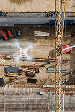
DJI Terra electricity version is optimised for power line modeling which enables 3D reconstruction of power lines. Based on an intelligent reconstruction algorithm large-scale data can produce high-quality reconstructions in a short time frame.
Features
Optimizations made specifically for power line modeling allow for detailed 3D reconstructions of thin power lines and complex structures. The CUDA-based reconstruction algorithms are capable of quickly processing large amounts of data to deliver quality results.
| Public Safety | Construction | Infrastructure | Agriculture | Filming |
|---|---|---|---|---|
|
Achieve rapid turn-around time for gathering on-site critical information
|
Collect, measure and analyze data with accuracy across projects |
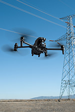
Easily perform detailed inspections on complex assets and structures |
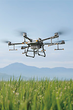
Get an in-depth understanding of your field to help you generate greater yields |
Optimise visualisation to improve planning workflows across your team |
Waypoints Mission Planning
Create efficient flight paths using predefined waypoint actions and adjustable parameters like altitude, speed, gimbal pitch angle, aircraft heading and more. For more complex and tight missions that require high attention to detail, use 3D Flight Visualization to design and simulate tasks on existing 3D models.
Area Mission Planning
With just a few taps on the screen, you can automate complex missions, allowing you to seamlessly capture imagery which can be processed to produce a variety of maps and models for further analysis, and to aid decision-making.
Oblique Mission Planning
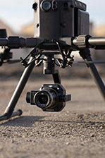
When accuracy is essential and details are vital to your critical operations, Oblique lets you capture a rich 3D model data set by adjusting the angle of the camera at a tilted angle, giving you an extra crisp view of the asset.
Mapping
Real-time Mapping
With real-time mapping, you can quickly generate a 2D orthomosaic of the selected area of the flight mission in real-time. Not only is this ideal for creating detailed flight paths in remote areas but it’s also useful for time-sensitive missions that require quick decision-making on site.
2D Reconstruction
Generate high-resolution orthomosaic, enabling you to get detailed and accurate measurement results for all your critical projects.
3D Reconstruction
Get sharp and realistic representations of your surroundings throughout various industrial applications, be it accident reconstruction, tracking progress on major construction projects and more.
Data Analysis
2D & 3D measurements
Acquire key dimensions across an array of terrains with easy-to-use analysis tools that enable you to obtain a variety of measurement data based on linear, area and volumetric measurements.
Annotation
Edit labels of measurements on existing models, which can be used for reporting and improving communication throughout ongoing projects.
Photo Inspection
Closely inspect every photo of the model so you can pinpoint and highlight any critical elements in the real world.
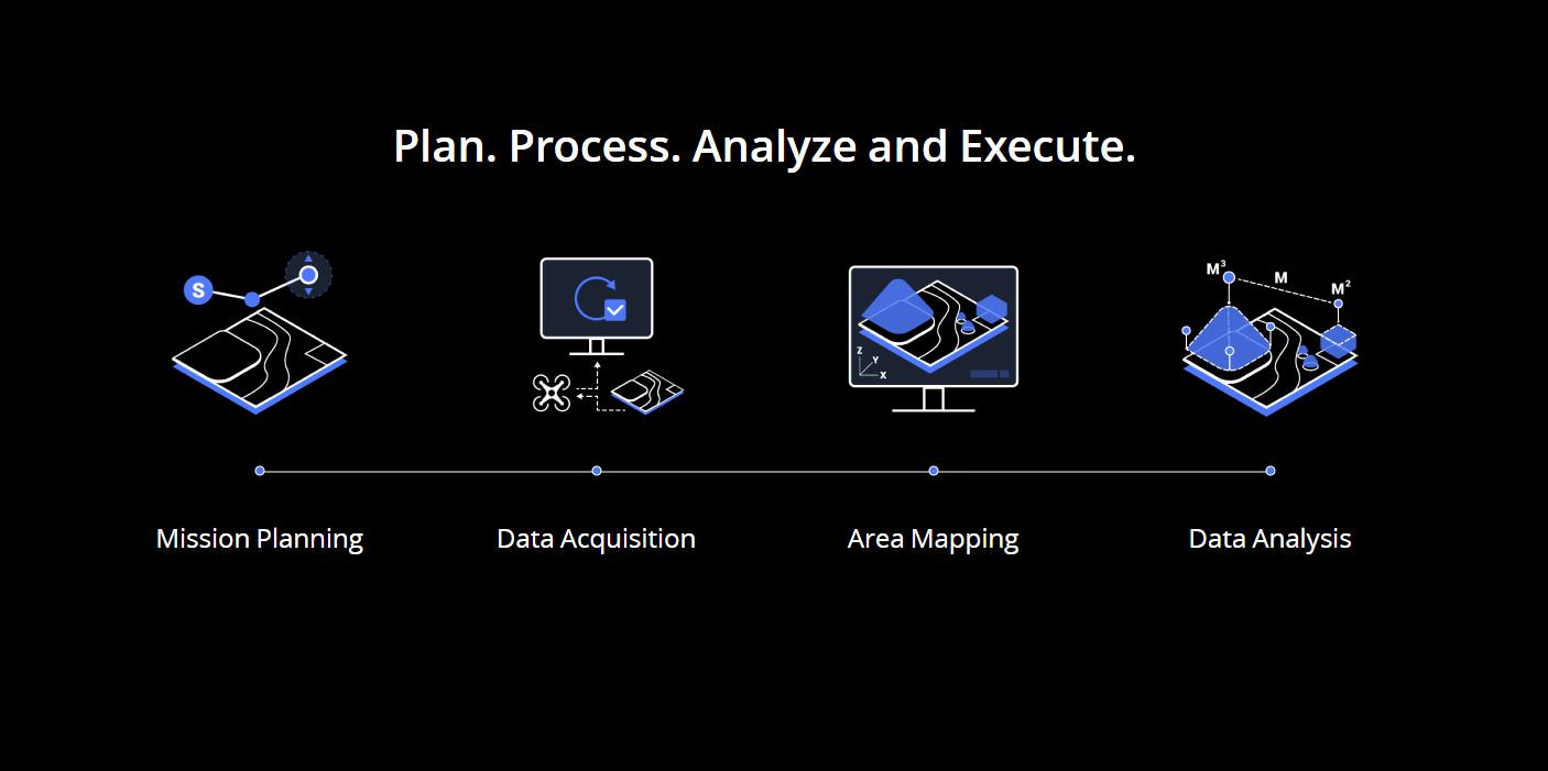
Next Generation Mapping Solutions
Harness the power of AI-driven mapping solutions designed to take your industrial projects to the next level. Whether it’s object classification, site inspections and more, you can start developing task-specific mapping solutions to seamlessly carry out missions.
Data acquisition
Define mission objective, plan desired flight plan, and with a tap of a few buttons, autonomously collect critical data so you can achieve the required outcome.
Data Processing
Utilize refined image recognition technology to generate 2D and 3D data, resulting in a more realistic representation of your assets, objects, surroundings and more.
Data Application
Implement tools and machine learning techniques, which can be used across a variety of different industries – like classification algorithms for identifying trees, objects, and other scenarios.
Execution
Take the required action, and enjoy more efficient processes with machine control – be it automated crop spraying, monitoring work sites, transporting materials and more.
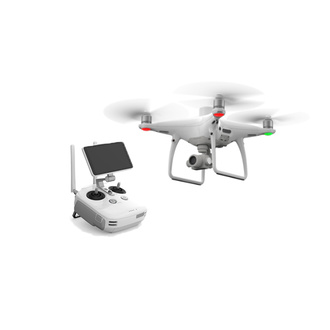
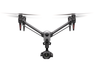
DJI Terra is compatible with the following Phantom 4 Series drones:
Phantom 4 RTK
Phantom 4 Pro V2.0
Phantom 4 Pro + V2.0
Phantom 4 Pro
Phantom 4 Advanced and Phantom 4
In the box
WHY BUY FROM US?
By buying from Ferntech, you'll have the confidence that you are dealing directly with New Zealand's leading drone experts. Our staff are knowledgable drone pilots who offer expert advice, trusted support and superior specialist service. Only through us will you receive a full New Zealand warranty, phone and email support, and access to our certified Repairs Centre with DJI-qualified drone technicians. And we guarantee that we will have the best prices on the market — if not let us know and we will match any price (conditions apply).
Warranty Details
Purchase And Preparation
How do I purchase DJI Terra?
DJI Terra Advanced and Pro can be purchased through authorized DJI resellers.
For how long will my DJI Terra license be effective?
The DJI Terra Advanced and Pro plans are only valid for one year.
Your license comes into effect starting the day the device is bound to DJI Terra.
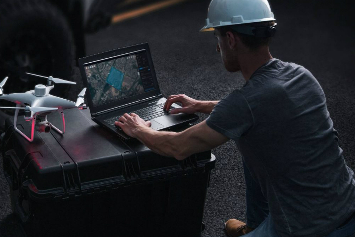
What do I need to start using DJI Terra?
1. A Phantom 4 Series drone that supports DJI Terra, several batteries;
2. A laptop, a microSD card and a card reader;
3. A compatible cable (a USB-to-USB cable for Phantom 4, Phantom 4 Pro, Phantom 4 Advanced, a Micro-USB cable for Phantom 4 Pro + V2.0, a USB-C cable for Phantom 4 RTK).
What are the computer system requirements for 2D and 3D reconstruction with DJI Terra?
A Windows 7 or above (64 bits) system is required when using the DJI Terra.
Minimum hardware configuration: 16GB RAM and a NVIDIA graphics card with at least 4GB VRAM (must have a compute capability of 3.0 or above).
Recommended hardware configuration: at least 32GB RAM and at least a NVIDIA 1050 Ti.
With these configuration requirements met, every additional 10 GB of RAM will be able to process 1000 additional 4K images. The higher the system configurations, the larger the number of images that can be processed and the faster the reconstructions. The results from the models generated will not be affected by different hardware configurations.
Which aircraft are supported by DJI Terra?
Phantom 4 RTK (Remote Controller), Phantom 4 Pro V2.0, Phantom 4 Pro+ V2.0, Phantom 4 Pro, Phantom 4 Advanced and Phantom 4. The Phantom 4 does not support 2D Real-time Mapping.
Can I still use the paid features of DJI Terra with no internet connection?
While connected to the internet, log into your account and bind a computer to the license so you can use the paid features of DJI Terra within the next 2 days even if you are not connected to the internet.
Why am I unable to switch the remote controller to PC Mode?
There are three possible reasons cause this problem:
(1)Drivers not installed. Connect the remote controller to DJI Terra via a USB cable. If a yellow exclamation point appears on the Device Manager’s serial port connection, you will need to install a driver; right-click to install the driver.
(2)The Phantom 4 Pro+ remote controller (with display) fails to connect with DJI Terra.
(3)Your remote controller has an HDMI module. Only remote controllers without an HDMI module, with a USB port and a Micro USB port, can be switched to PC mode.
*Phantom 4 RTK and Phantom 4 Pro V2.0 series aircraft need not to be switched to remote controller mode.
Can I unbind devices from DJI Terra licenses?
You can unbind your DJI Terra Advanced and Pro licenses. To unbind, please contact DJI Support. The 1-device licenses can be unbound once in each natural year. 3-device licenses can be unbound twice in each natural year. Once processed, all devices registered under the license will be unbound.
Flight And Aerial Photography
What is the difference between Waypoints Mission, Mapping Mission, Oblique Mission and Corridor Mission?
Waypoints Mission: plan a flight route and capture photos or videos at waypoints along the route.
Mapping Mission: collect images of an area to reconstruct a 2D model.
Oblique Mission: collect images of an area from multiple camera angles to reconstruct a 3D model.
Corridor Mission: collect images of a corridor (e.g. rivers, railroads) to reconstruct a 2D model.
Why are there 5 flight routes when I plan an Oblique Mission in DJI Terra?
DJI Terra’s Oblique Mission uses 5 flight routes to capture the same amount of data as using 5 cameras simultaneously on a drone. The 5 flight routes correspond to the 5 camera headings – downward, forward, backward, leftward, and rightward.
How do I plan flight routes when there is no internet connection and the map cannot be loaded?
If you have access to a mobile device that has an internet connection (such as a cellphone), you can turn on the hotspot so that the laptop can be connected to the internet.
If the site where you are operating has no internet signal, you can pre-plan the flight route while you are indoors and have an internet connection, or manually fly the drone around the area to be mapped to set boundaries points to plan flight routes.
What is Ground Sample Distance (GSD)?
In photogrammetry and remote sensing, ground sample distance (GSD) in an aerial digital photo (such as an orthophoto) of the ground is the actual distance on the ground captured as represented by pixels. The unit is cm/pixel.
In the New Mapping Mission page, what does Relative Height in Advanced Settings mean? How is it different from Mission Altitude in Basic Settings?
Relative Height in Advanced Settings is the height of the takeoff point relative to the area being mapped. Mission Altitude is the height of the drone relative to the area being mapped, which is also how ground sample distance (GSD) is calculated.
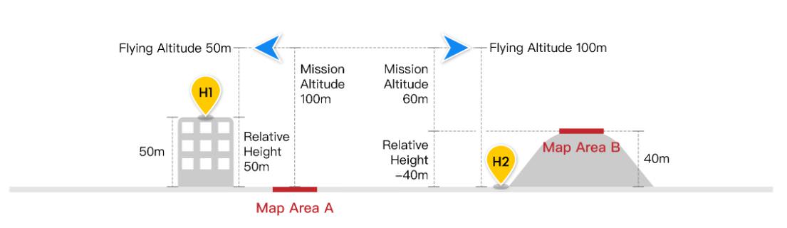
When do I have to adjust the Relative Height in Advanced Settings?
When there is a large difference between the elevation of the takeoff location and the elevation of the area being mapped, you can adjust the Relative Height in Advanced Settings to ensure that the Mission Altitude is determined considering the elevation of the area being mapped. Please see the attached illustration: If the drone takes off from a 50m building marked H1 in the illustration, the area being mapped is marked A, and the expected altitude for aerial data collection is 100m, you can set the Mission Altitude in Basic Settings to 100m, and Relative Height in Advanced Settings to 50m. Similarly, if the drone takes off from H2 to map area B, which is a hill with an elevation of 40m, and the expected altitude for aerial data collection is 60m, then set Mission Altitude to be 60m, and Relative Height to be -40m.
What should I do to ensure accuracy in my missions when collecting data with the Phantom 4 RTK?
1) Conduct your missions in clear weather conditions with high visibility.
2) Check the images and videos for brightness and clarity immediately after your mission.
3) During a surveying mission, avoid areas with strong electromagnetic interference or obstructions to ensure the accuracy of the attitude algorithm of the Phantom 4 RTK. Also make sure that the remote controller is properly linked to the aircraft.
4) Ensure there is enough forward and side overlap. It is recommended to have a forward overlap rate of 80% and a side overlap rate of 70%. Overlap rates can be adjusted depending on the terrain.
When should I adjust the overlap rates based on the terrain?
It is recommended to have a forward overlap rate of 80% and a side overlap rate of 70%, which should meet the requirements for most application scenarios. The overlap rate can be increased when the area being mapped has a large difference in elevation to ensure the highest point mapped has enough overlap. When the area mapped is relatively uniform in elevation, the overlap rate can be adjusted lower to reduce the amount of data that needs to be processed, making the mapping mission more efficient. However, it is recommended to keep the forward overlap at a minimum of 65% and side overlap at a minimum of 60%.
When I connect DJI Terra to Phantom 4 RTK, the app tells me that I cannot take off because the RTK signal is too weak. What should I do?
It could be that you are operating somewhere with a lot of signal interference or obstructions, which affects the strength of the RTK signal. Try turning off the RTK module and take off manually with the GNSS positioning. Once the drone reaches a height where there is less interference, you can turn on the RTK module and connect to DJI Terra to conduct your flight missions.
Which aircraft support Real-time 3D Point Cloud?
Phantom 4 RTK (Remote Controller), Phantom 4 Pro V2.0, Phantom 4 Pro + V2.0. Note: point clouds may be of poor quality be unavailable in environments without RTK signals.
Can I plan flight routes for Waypoints Missions based on real-time 3D point clouds?
Yes.
Building Reconstruction Models
Why is my computer stuck when processing images locally to reconstruct a model? Can I run DJI Terra while running other programs?
To build reconstruction models as quickly as possible, DJI Terra uses all the computer resources available, including the CPU, RAM, and VRAM of the graphics card, which could make the computer slower while running DJI Terra but should not be a problem once the processing is finished. It is recommended that you don’t run other programs that might be GPU-intensive while running DJI Terra, as doing so could result in failure of model reconstruction.
What are the Field, Urban, and Fruit Tree Scenarios in 2D Map?
The Field Scenario is designed to capture data from relatively flat land, for example, rice or wheat fields.
The Urban Scenario is designed for areas with buildings of different heights.
The Fruit Tree Scenario is designed for orchards that might have a large variety of elevations and heights. The 2D mapping algorithms are optimized for the three specific scenarios, so you can choose the one that best fits your mission type.
Why is there a large discrepancy between the elevation results in the digital surface model (DSM) of the 2D map generated by DJI Terra and the actual elevation measured via RTK?
The location information on aerial images collected by a drone that’s not equipped with RTK is not the most accurate, which will result in a difference between the elevation in the digital surface model (DSM) and the actual elevation.
When conducting missions with the Phantom 4 RTK, if the 2D map is generated with only the Nadir view images collected, the precision of the DSM will be limited, which is why it is recommended to incorporate oblique imagery in building the 2D map to enhance precision. This can be done by setting the gimbal pitch to -45° and circling the point of interest during flight.
What is the difference between 3D Reconstruction in Mapping Mission and in Oblique Photography Mission?
There is no difference. If only Nadir view images are available, it is recommended to use a mapping mission for building 2D maps. If oblique photos are available, you can choose an oblique photography mission.
How different are the 3D models built at different resolutions? How long does it take to build models at these resolutions?
There are three options for reconstruction resolution: high, medium, and low, which will generate models at full, half, and quarter resolution respectively. The higher the resolution the better the quality of the reconstructed models. The rough ratio of time consumption for reconstruction at high:medium: low resolutions is about 16:4:1.
Why are there gaps in my model? What are some factors that affect the quality of the reconstruction?
Gaps in the model can be due to missing shots of the area being mapped, or images taken at poor angles. The quality of reconstruction can be affected by factors such as reflective surfaces in the area (water or glass), or large areas of the same color or pattern (white walls, skies).
Can I trim or edit the 3D models generated in DJI Terra?
DJI Terra will trim around a POI 3D model automatically, but will not trim other models. If you would like to edit the model, you can export it and edit in another software.
What files can I get from the 2D maps and 3D models built in DJI Terra?
In addition to the map tiles shown in the app’s interface, DJI Terra’s 2D maps provide digital orthophoto maps and digital surface models in the GeoTIFF format used with UTM projection. DJI Terra’s 3D model reconstructions contain texture mesh in .ply or .obj, level of detail model in .osgb or .b3dm, and point cloud in .las
How do I view the results and files from my 2D maps and 3D models?
You can click the More button in each Mission and open the file folders where the files generated from the missions are stored. You can also use Ctrl + Alt + F to quickly go to the folder. 2D maps are stored under “map” and 3D models are stored under “models”.
To view log files, use Ctrl + Alt + L.
What variables might affect the accuracy of the 2D and 3D reconstructions in DJI Terra?
The accuracy of the reconstruction can be affected by factors such as camera distortion, image quality, flight height, side and forward overlap settings, GPS (RTK) positioning accuracy and the area’s texture information.
What is the accuracy when building 2D maps and 3D models with the Phantom 4 RTK?
When using the Phantom 4 RTK, the absolute accuracy achieved by the 2D maps in DJI Terra is around 1 to 2 times the GSD, which is a similar level of accuracy as other data processing software. When flying at 100m height, the absolute horizontal accuracy of the 2D map is 2-5cm, and the absolute accuracy of the 3D models is within 4cm.
Can I run multiple missions on the same computer?
Due to limitations in the computer’s processing capacity, you can only run multiple reconstructions at the same time. They will be processed in the order in which they are added to the lineup.
Can I output a point cloud with the 3D reconstruction?
Yes. The point cloud output will be in LAS format.
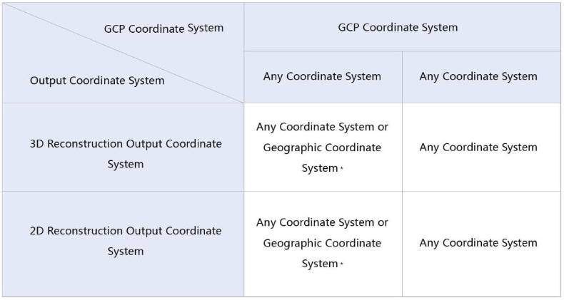
Output Coordinate System
What’s the purpose of setting an output coordinate system?
The following reconstruction results can be delivered in specified coordinate systems.
2D Reconstruction Results: dsm.tif、result.tif
3D Reconstruction Results:
LAS files, OBJ files, PLY files, OSGB files. Each file comes with a coordinate system instruction file metadata.xml.
Why do I get an “Output Coordinate System Error” pop-up after I set the output coordinate system and click Reconstruct?
This error will pop up if reconstruction results cannot be converted to the specified coordinate system. The output coordinate system has to do with GPS information on the images and the coordinate system the GCPs are in. Here are some scenarios that you might want to consider:
(1) Aerial triangulation without GCPs

(2) Aerial triangulation optimized with GCPs
Ground Control Points (GCPS)
What are Ground Control Points? How to obtain Ground Control Points?
Ground Control Points (GCPs) are marked points on the ground with known coordinates and are clearly visible in an image. GCPs can be obtained using photogrammetry methods such as GPS-RTK or a total station.
Why use GCPs?
GCPs help increases the robustness and accuracy of aerial triangulation, check the accuracy of the aerial triangulation against actual measurements, and determine absolute orientation by converting the aerial triangulation result into GCPs in the designated coordinate system.
What should be noted when importing GCP files?
The GCP data should be in this order: point name, latitude/X, longitude/Y, height/Z, horizontal accuracy, vertical accuracy). Accuracy data is optional. The first row is to coordinate data, and each column is separated with space or a tab. In the projected coordinate system, X represents the East, and Y represents the North.
What are the differences between GCPs and checkpoints?
GCPs are used to optimize the result of aerial triangulation. It would take at least three GCPs to ensure absolute orientation for aerial triangulation. Checkpoints are used to check for the absolute accuracy of aerial triangulation by comparing the error between the result calculated with aerial triangulation and the actual measurements. It is recommended to use no less than four GCPs for calculation in each target area. When you have an abundant number of GCPs, you can choose to set some of them as checkpoints to check for accuracy.
How accurate should the GCPs be?
GCPs values are used in aerial triangulation, and the accuracy should correspond to the final absolute accuracy that your project needs. The smaller the accuracy settings, the stronger the GCP’s contribution will be to the triangulation model.
What is a GCP reprojection error?
When computing a point and GCPs have been marked on at least 2 images, the 3D coordinates will be calculated and reprojected onto all images in which the point appears. The difference between the marked point and reprojected point on the image is the reprojection error. the average of different reprojection errors is shown in DJI Terra as the reprojection error.
What is a GCP 3D error?
The 3D error of a GCP refers to the spatial difference between its measured coordinates and 3D coordinates obtained by conducting space intersection with the elements of interior and exterior orientations of the image.
What are some ways to optimize the results after marking a GCP?
Given that the coordinate system in which aerial images and GCPs have been acquired can be converted using DJI Terra, i.e. the images and GCPs use the same coordinate system geodetic datum:
a) For images with high positioning accuracy, for instance, ones acquired using the Phantom 4 RTK, GCP projections will not be far off from actual measurements. Mark the GCPs with reference to their projected results on the image, and then click “aerial triangulation” on the screen.
b) For images with low positioning precision, you can run aerial triangulation first with the imported images that contain GPS information, and then import the measured coordinates of the GCPs. After the first triangulation, you can proceed with marking the GCPs and run an optimization by pressing “optimize” on the screen.
What is the difference between aerial triangulation and optimization?
Optimization is done to improve the results of aerial triangulation. If triangulation is done immediately after marking GCPs, checkpoints will also be used in the calculation, which is not ideal. A better process will be: aerial triangulation enter GCP coordinates and mark them against projected coordinates on the image optimize. By doing so, GCPs are used to improve the accuracy of aerial triangulation.
I have imported all images and am now on the GCP Management page, but why do I not see the position and attitude information of the camera?
Make sure the positioning and attitude information of the imported images is correct.
Why are the GCPs and camera attitude/position not showing up in the right place after importing GCPs?
Make sure the positioning and attitude information on the images are correct and choose the same coordinate system as the one that the GCPs are set in.
Why is the accuracy of checkpoints lower after optimization using GCPs?
The accuracy of aerial triangulation and optimization are affected by three factors: error in GCP marking, error in coordinate measurement, and the distribution and number of GCPs within the mapping area. We recommend you choose at least four GCPs distributed evenly across the target area. Each GCP should appear in at least four images at different locations and avoid having it near the edge of an image.
Does DJI Terra support GCP processing for images taken with other DJI drones?
Yes.
2D Multispectral Reconstruction
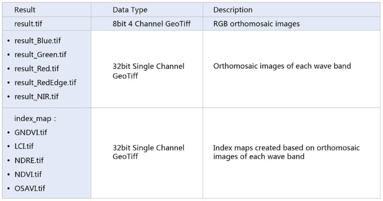
What results can be exported from a 2D multispectral reconstruction?
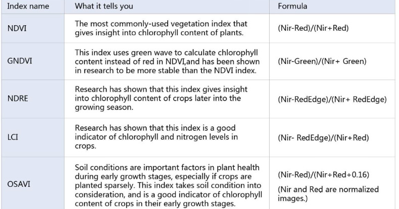
How are the vegetation indices calculated in the 2D multispectral reconstruction and what do they mean?
Does the 2D Multispectral Construction mode also support data from other multispectral cameras other than the P4 Multispectral?
Currently, no.
Can I create 2D multispectral reconstructions without importing RGB images?
No. Currently, RGB images are required for 2D multispectral reconstructions.
Other
Can I modify the location where my 2D and 3D reconstructions are saved?
Yes. The default path is C:\Users\***(User Name)\Documents\DJI\DJI Terra. You can modify the path by going
to the settings  Cache directory.
Can I import models generated in DJI Terra into other software programs, such as Maya, Blender, SketchUp, and 3ds Max?
Yes, the .obj files generated in DJI Terra can be imported into Maya, Blender, SketchUp, and 3ds Max. Look up tutorials for the specific process for each software.
Can I embed a 3D model into a webpage?
Yes, .b3dm, .osgb, .ply and .obj files generated by DJI Terra are universal file formats and can be embedded into webpages. You can find instructions for embedding each of these formats online.
Can I use non-aerial images to build 2D or 3D models?
Theoretically, they can be used to reconstruct 3D models although the quality might suffer. They cannot be used to build 2D reconstructions.
Can I process images taken from non-DJI drones in DJI Terra to build 2D and 3D reconstructions?
Theoretically yes for 3D models, but the results might not be as good as if you were to use DJI drones. The quality of the reconstructions will benefit from GPS or RTK positioning data on the images. 2D reconstructions are not supported.
There's currently no reviews for this product, be the first to write one.