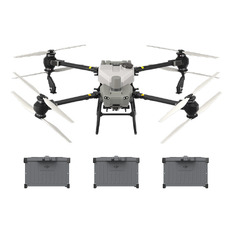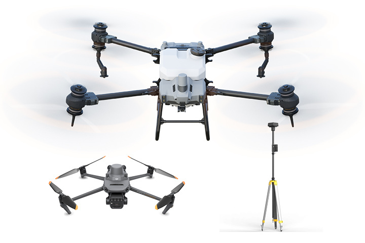
DJI Agras T40 Multispectral and Base Station Combo
The DJI Agras T40 Multispectral and Base Station Combo includes the Agras T40, Mavic 3 Multispectral and the D-RTK 2 Base Station 2.
The DJI Agras T40 Multispectral and Base Station Combo includes:
DJI Agras T40 Combo
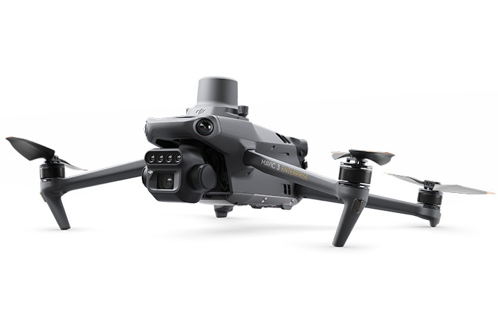
DJI Mavic 3 Multispectral Combo
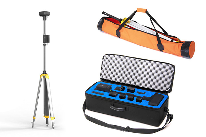
DJI D-RTK 2 Base Station Combo
Features
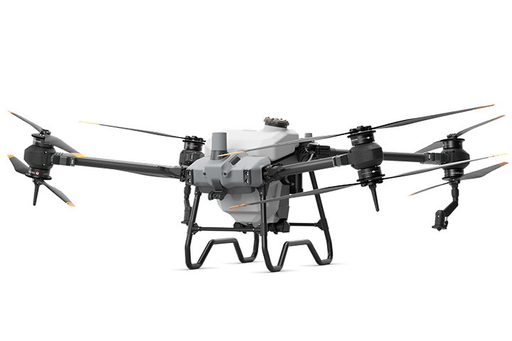
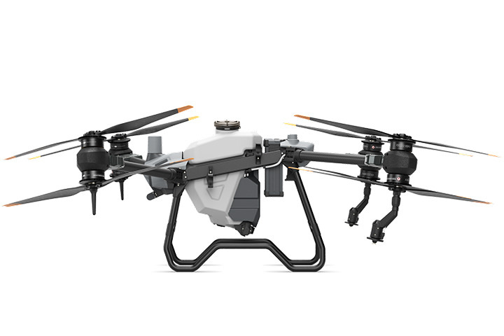
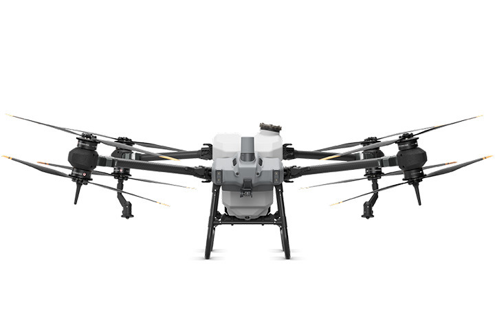
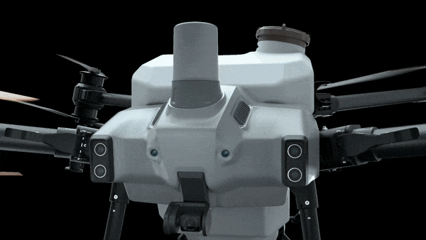
One For All
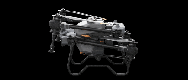
The AGRAS T40 is equipped with the revolutionary Coaxial Twin Rotor design, enabling it to carry a spray load of 40 kg and a spread load of 50 kg (70 L). The aircraft is built in with a Dual Atomized Spraying System, DJI Terra, Active Phased array Radar and Binocular Vision. It supports multiple missions from surveying, mapping, to spraying and spreading, helping you achieve ultimate precision in your agricultural operations.
50KG SPREADING PAYLOAD | 40KG SPRAYING PAYLOAD
ACTIVE PHASED ARRAY RADAR + BINOCULAR VISION
DUAL ATOMIZED SPRAYING SYSTEM
SUPPORTS FLIGHT SPRAYING/SPREADING AND RC MAPPING
CORE MODULES IPX6K
EFI GENERATOR 15% FUEL SAVING
52 ACRES (21.3 HECTARE) PER FLIGHT HOUR
36 FT (11M) SWATH (SPRAY WIDTH)
Massive payload increase thanks to the coaxial twin rotor
The AGRAS T40 features a coaxial twin rotor design that increases the payload capacity by 30% with a maximum payload of 50 kg. Its foldable design reduces the aircraft size by 70% for greater portability.
Spraying System
Dual atomization for even spraying
The all-new dual atomized centrifugal nozzles have two spinners that make the droplets more uniform in size, avoid splashing, and dripping, and prevent clogging when spraying powder-based chemicals.
Magnetic Drive Impeller Pump
The new magnetic transmission design completely isolates the pesticide from the motor, making the aircraft corrosion-proof and ultra-durable. Quick disassembly by hand for easy cleaning
Dual Atomized Centrifugal Sprinkler
The dual atomized spray disc ensures even droplets and more efficient pesticide usage. The proprietary centrifugal valve prevents leakage, avoids over-fertilization, and reduces pesticide use while protecting the environment
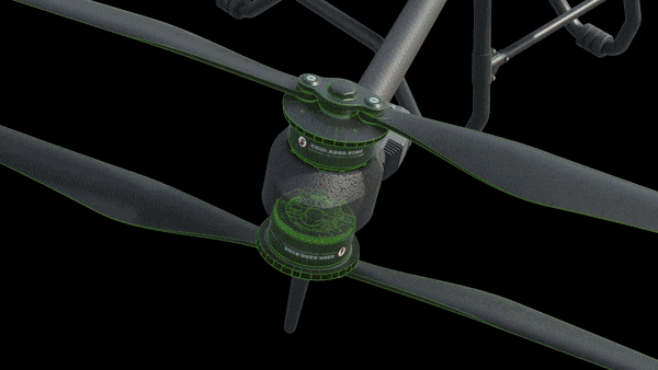
Active Phased Array Radar + Binocular Vision
Omnidirectional Obstacle Sensing
The Active Phased Array Radar is incorporated with a binocular vision sensor system to provide 360-degree horizontal omnidirectional obstacle sensing, offering optimal security. The detection distance of up to 50 m[8] allows for intelligent terrain following, smooth scaling and bypassing of multiple obstacles[9].
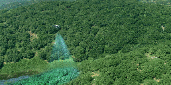
Mapping, spraying and spreading, all in one
The AGRAS T40 combines mapping, spraying and spreading functions, while its UHD camera and adjustable gimbal enable easy capture of your desired view. Farmland and orchard images can be captured in real time, and local maps can be generated using the remote controller with the D-RTK 2 Mobile Station. The system detects land boundaries and obstacles automatically, for quicker planning of flight routes over farmland and hilly orchards.
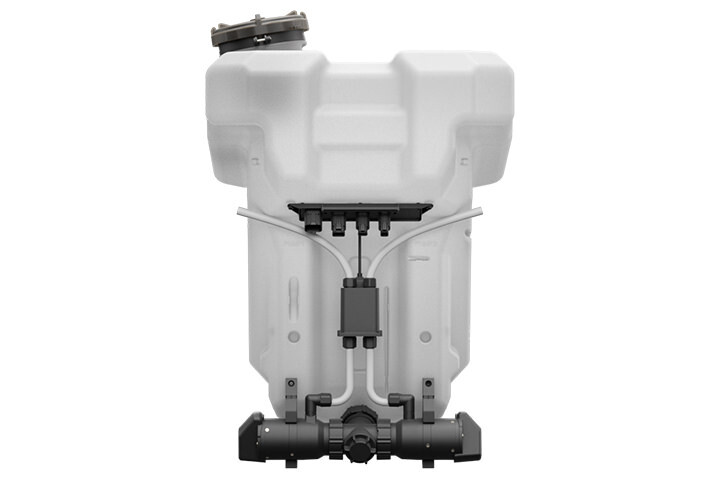
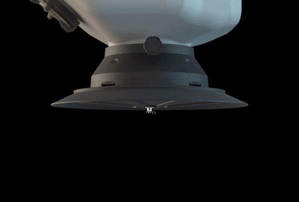
T40 spreading system
Enhanced spreading efficiency for superior performance
Real-time weighing
The aircraft is equipped with a weighing sensor that monitors the spread quantity and remaining payload
Fast disassembly and cleaning
The spreading device can be dismantled in 3 minutes and washed with water.
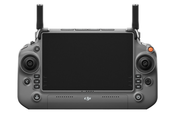
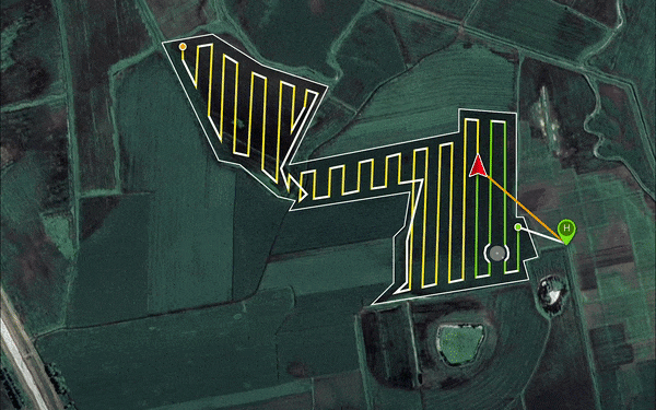
Fully enhanced remote controller for smoother, faster mapping
The 8-core processor makes mapping of 6.67 hectares possible in 10 minutes. Minimizes wasted journeys with intelligent route planning, for greater efficiency. The large 7-inch high brightness screen offers a broader view with refined detail. A wide range of custom physical buttons provides flexible control.
Robustly tested for ultimate reliability
The core components are designed to withstand complex and harsh farmland environments. They have passed a host of rigorous tests such as corrosion prevention, high and low temperature, and aging tests, to ensure peace of mind for the user.
Ultra-fast charging
12000W Multifunctional Inverter Generator with new EFI technology and 15% fuel saving. The charging station produces 1500W AC output, sufficient to power the remote controller, water pump, reloader, lights, and other components. The 30000mAh Intelligent Flight Battery with its standard air-cooled heat sink can cool down rapidly.
D12000iE Multifunctional Inverter Generator
30L tank charges 47 batteries | 1500W AC output | 9-min ultra-fast charging
T40 Intelligent Flight Battery
Capacity up to 30000 mAh | 11.5C while discharging, 6C while charging | Warranty coverage of 1,500 charging cycles
DJI Agras Intelligent Cloud
By pairing AGRAS T40 with the Mavic 3 Multispectral, the platform allows you to perform variable spraying/spreading operations with precision based on the farmland’s prescription map. The feature is useful for the spraying of fertilizers on rice, fertilizers and defoliants on cotton crops, and nutrient solutions on soybeans and corn.
Precise variable spraying on rice crops, for lower pesticide usage and increased productivity
In 2021, Jiangsu Farming Group reduced its fertilizer consumption by 10% and increased its rice and wheat yield by 5% by spraying fertilizers in variable quantities on its crop fields.
Call our commercial team at 0800787623 for more details
Product Specifications
Agras T40
Aircraft Parameters
Total weight
38 kg (without battery)
50 kg (with battery)
Max Takeoff Weight[1]
Max takeoff weight for spraying: 90 kg (at sea level)
Maximum takeoff weight for spreading: 101 kg (at sea level)
Max Diagonal Wheelbase
2184 mm
Dimensions
2800 mm × 3150 mm × 780 mm (arms & propellers unfolded)
1590 mm × 1930 mm × 780 mm (arms unfolded, propellers folded)
1125 mm × 750 mm × 850 mm (arms folded)
Hovering Accuracy Range (with strong GNSS signal)
RTK positioning enabled:
±10 cm horizontal, ±10 cm vertical
RTK positioning disabled:
±60 cm horizontal and ±30 cm vertical (radar enabled: ±10 cm)
RTK/GNSS Operating Frequency
RTK: GPS L1/L2, GLONASS F1/F2, BeiDou B1/B2, Galileo E1/E5
GNSS: GPS L1, GLONASS F1, Galileo E1, BeiDou B1
Hovering Time[2]
Hovering without payload: 18 min (@30000 mAh & takeoff weight 50 kg)
Hovering and spraying with full payload: 7 min (@30000 mAh & takeoff weight 90 kg)
Hovering and speading with full payload: 6 min (@30000 mAh & takeoff weight 101 kg)
Max flight radius can be set
2000 m
Max Wind Resistance
6 m/s
Propulsion System - Motor
Stator Size
100×33 mm
Motor KV Value
48 RPM/V
Motor Power
4000 W/rotor
Propulsion System - Propeller
Diameter
54 inch
Rotor Quantity
8
Dual Atomized Spraying System - Operation Box
Operation Box Capacity
Full load 40 L
Operating Payload
Full load 40 kg[1]
Dual Atomized Spraying System - Sprinkler
Sprinkler Model
LX8060SZ
Sprinkler Quantity
2
Droplet Size
50-300 μm
Max Effective Spray Width[3]
11 m (relative operating altitude 2.5 m, flight speed 7 m/s)
Dual Atomized Spraying System - Water Pump
Pump Model
Magnetic Drive Impeller Pump
Max Flow Rate
6 L/min*2
T40 Spreading System
Applicable Materials
Solid dry particles with a diameter of 0.5 to 5 mm
Spread Tank Volume
70 L
Spread Tank Internal Load
50 kg[1]
Spread Width of Spreading System[4]
7 m
Recommended Operating Temperature
0°C to 40°C (32°F to 104°F)
Active Phased Array Omnidirectional Radar
Model Number
RD2484R
Terrain Follow
Max incline: 30°
Obstacle Avoidance[5]
Sensible distance (horizontal): 1.5-50 m
FOV: 360° horizontal, ±45° vertical
Operating conditions: Flying higher than 1.5 m over the obstacle at a speed not exceeding 7 m/s
Safe distance: 2.5 m (distance between the propeller tip and obstacle when the aircraft is hovering after braking)
Sensing direction: horizontal omnidirectional avoidance;
Sensible distance (above): 1.5-30 m
FOV: 45°
Operating conditions: Available during takeoff, landing, and ascending when an obstacle is more than 1.5 m above the aircraft
Safe distance: 2.5 m (distance between the top of the aircraft and the obstacle when the aircraft is hovering after braking)
Sensing direction: Upward
Active Phased Array Backward and Downward Radar
Model Number
RD2484B
Altitude Detection[5]
Within the altitude detection range: 1-45 m
Fixed altitude range: 1.5-30 m
Rear Obstacle Avoidance[5]
Sensible distance (rear): 1.5-30 m
FOV: ±60° horizontal, ±25° vertical
Operating conditions: Available during takeoff, landing, and ascending when an obstacle is more than 1.5 m behind the aircraft and the flight speed does not exceed 7 m/s
Safe distance: 2.5 m (distance between the propeller tip and obstacle when the aircraft is hovering after braking)
Sensing direction: backward
Binocular Vision System
Measurable Range
0.4-25 m
Effective Sensing Speed
≤7 m/s
FOV
Horizontal: 90; Vertical: 106°
Work Environment Requirements
Normal lighting with clearly textured surfaces
Intelligent Remote Controller
O3 Pro Operating Frequency[6]
2.4000 to 2.4835 GHz
5.725 to 5.850 GHz
O3 Pro Signal Effective Distance
SRRC: 5 km
MIC/KCC/CE: 4 km
FCC: 7 km
(aircraft altitude at 2.5 m in an unobstructed environment with no interference)
Wi-Fi Protocol
WIFI 6
Wi-Fi Operating Frequency[6]
2.4000 to 2.4835 GHz
5.150 to 5.250 GHz
5.725 to 5.850 GHz
Bluetooth Protocol
Bluetooth 5.1
Bluetooth Operating Frequency
2.4000-2.4835 GHz
Location
GPS + Galileo + BeiDou
Display Screens
7.02-inch touch LCD with 1920*1200 resolution and 1200cd/m brightness2
Supported Aircraft
AGRAS T40, AGRAS T20P
Operating temperature
-20°C to 50°C (-4°F to 122°F)
Storage Temperature Range
-30°C to 45°C (within one month)
-30°C to 35°C (between one month and three months)
-30°C to 30°C (between three months and one year)
Charging Temperature
5° to 40°C (41° to 104°F)
Internal Battery Life
3.3 hours
External Battery Life
2.7 hours
Charging Type
Use a USB-C charger with a maximum rated power and voltage of 65 W and 20 V. The DJI Portable Charger is recommended.
Charging Time
Two hours for both internal and internal plus external batteries (to use the official charging method when the aircraft is off)
T40 Intelligent Flight Battery
Model
BAX601-30000mAh-52.22V
Weight
Approx. 12 kg
Capacity
30000 mAh
Voltage
52.22 V
D12000iE Multifunctional Inverter Generator
Output Channel
1. DC charging output 42-59.92V/9000W
2.Power supply for air-cooled heat sink 12 V/6 A
3.AC output 230V/1500W or 120V/750W [7].
Battery Charging Time
To fully charge one battery (T40 battery) takes 9-12 mins
Fuel Tank Capacity
30 L
Starting Method
Starting the Generator via the One-Button Start Switch
Max Power of Engine
12000 W
Fuel Type
Unleaded gasoline with RON ≥91 (AKI ≥87) and alcohol content less than 10%
(*Brazil: unleaded gasoline with RON ≥ 91 and alcohol content of 27%)
Reference Fuel Consumption [8]
500 ml/kWh
Engine Oil Model
SJ 10W-40
Definition
[1] Data was measured at sea level. The payload weight is greatly affected by the ambient temperature and altitude. The payload weight needs to be reduced by 10 kg for every 1,000m increase in altitude. The DJI Agras app will recommend the payload weight according to the current status and surroundings of the aircraft. When adding materials, the maximum weight should not exceed the recommended value, otherwise flight safety may be compromised.
[2] Hovering time measured at sea level with a wind speed lower than 3 m/s and ambient temperature of 25°C, when the battery power fell from 100% to 0%. The data is for reference only. The actual environment may differ from the testing environment. The figure listed is for reference only.
[3] The spray width of the spraying system depends on the operating scenario.
[4] The spread width of the spreading system depends on the operating scenario.
[5] The effective sensing range varies depending on the material, position, shape, and other properties of the obstacle.
[6] In some countries, the 5.1 and 5.8GHz frequencies are prohibited, or the 5.1GHz frequency is only allowed for indoor use. Please refer to local laws and regulations. [7] The actual power and voltage may vary according to local regulations
[8] Measured using RON 92 gasoline at near sea level with an ambient temperature of 25°C, while charging at 9 kW.
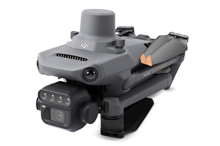
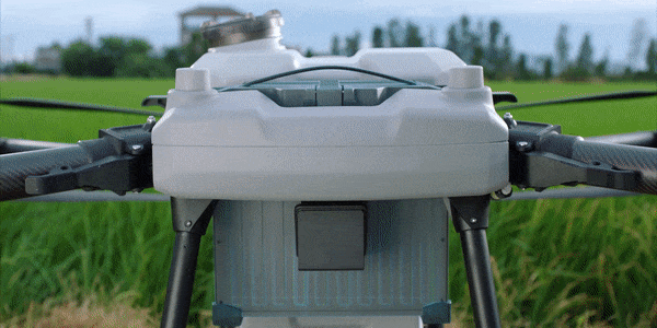
Mavic 3 Multispectral
Aircraft
Net Weight (with propellers and RTK module) [1]
951 g
Max Takeoff Weight
1,050 g
Dimensions (Folded/Unfolded)
Folded (without propellers): 223×96.3×122.2 mm (Length×Width×Height)
Unfolded (without propellers): 347.5×283×139.6 mm (Length×Width×Height)
Diagonal Length
Diagonal: 380.1 mm
Max Ascent Speed
6 m/s (Normal Mode)
8 m/s (Sport Mode)
Max Descent Speed
6 m/s (Normal Mode)
6 m/s (Sport Mode)
Max Flight Speed (at sea level, no wind)
15 m/s (Normal Mode)
Flying forward: 21 m/s, flying sideways: 20 m/s, flying backwards: 19 m/s (Sport mode) [2]
Max Wind Speed Resistance
12 m/s [3]
Max Take-off Altitude Above Sea Level
6000 m (without a payload)
Max Flight Time (without wind)
43 minutes [4]
Max Hover Time (without wind)
37 minutes [4]
Max Flight Distance
32 km [6]
Max Tilt Angle
30° (Normal Mode)
35° (Sport Mode)
Max Angular Velocity
200°/s
GNSS
GPS + Galileo + BeiDou + GLONASS (GLONASS is supported only when RTK module is enabled)
Hovering Accuracy Range
Vertical: ±0.1 m (Vision Positioning enabled); ±0.5 m (GNSS Positioning enabled); ±0.1 m (D-RTK enabled)
Horizontal: ±0.3 m (Vision Positioning enabled); ±0.5 m (HD Positioning enabled); ±0.1 m (RTK enabled)
Operating Temperature
-10° to 40° C (14° to 104° F)
Internal Storage
N/A
Motor Model Number
2008
Propeller Model Number
9453F Enterprise Edition
Light Sensor
Built-in module
RGB Camera
Image Sensor
4/3 CMOS
Effective Pixels: 20 MP
Lens
FOV: 84°
Equivalent focal length: 24 mm
Aperture: f/2.8 to f/11
Focus: 1 m to ∞
ISO Range
100-6400
Shutter speed
Electronic shutter: 8-1/8000 s
Mechanical shutter: 8-1/2000 s
Max Image Size
5280×3956
Photo Shooting Mode
Single shot: 20 MP
Timelapse: 20 MP
JPEG: 0.7/1/2/3/5/7/10/15/20/30/60 s
JPEG + RAW: 3/5/7/10/15/20/30/60 s
Panorama: 20 MP (original material)
Video Resolution
H.264:
4K: 3840×2160@30fps
FHD: 1920×1080@30fps
Max Video Bitrate
4K: 130Mbps
FHD: 70Mbps
Supported File System
exFAT
Image Format
JPEG/DNG (RAW)
Video Format
MP4 (MPEG-4 AVC/H.264)
Multispectral Camera
Image Sensor
1/2.8-inch CMOS, effective pixels: 5 MP
Lens
FOV: 73.91° (61.2° x 48.10°)
Equivalent focal length: 25 mm
Aperture: f/2.0
Focus: Fixed Focus
Multispectral Camera Band
Green (G): 560 ± 16 nm;
Red (R): 650 ± 16 nm;
Red Edge (RE): 730 ± 16 nm;
Near infrared (NIR): 860 ± 26 nm;
Gain Range
1x-32x
Shutter Speed
Electronic Shutter: 1/30~1/12800 s
Max Image Size
2592×1944
Image Format
TIFF
Video Format
MP4 (MPEG-4 AVC/H.264)
Photo Shooting Mode
Single shot: 5 MP
Timelapse: 5 MP
TIFF: 2/3/5/7/10/15/20/30/60 s
Video Resolution
H.264
FHD: 1920 x 1080@30fps
Video content: NDVI/GNDVI/NDRE
Max Video Bitrate
Stream: 60 Mbps
Gimbal
Stabilization System
3-axis mechanical gimbal (tilt, roll, pan)
Mechanical Range
Tilt: -135° to 45°
Roll: -45° to 45°
Pan: -27° to 27°
Controllable Range
Tilt: -90° to 35°
Pan: Uncontrollable
Max Control Speed (tilt)
100°/s
Angular Vibration Range
±0.007°
Sensing System
Sensing System Type
Omnidirectional binocular vision system, with an infrared sensor at the bottom of the aircraft
Forward
Distance Measuring Range: 0.5 m to 20 m
Detection Range: 0.5 m to 200 m
Effective Obstacle Avoidance Speed: Flight Speed ≤15 m/s
FOV: Horizontal 90°, vertical 103°
Backward
Distance Measuring Range: 0.5 m to 16 m
Effective Obstacle Avoidance Speed: Flight speed ≤12 m/s
FOV: Horizontal 90°, vertical 103°
Lateral
Distance Measuring Range: 0.5 m to 25 m
Effective Obstacle Avoidance Speed: Flight speed ≤15 m/s
FOV: Horizontal 90°, vertical 85°
Upward
Distance Measuring Range: 0.2 m to 10 m
Effective Obstacle Avoidance Speed: Flight Speed ≤6 m/s
FOV: Front and rear 100°, left and right 90°
Downward
Distance Measuring Range: 0.3 m to 18 m
Effective Obstacle Avoidance Speed: Flight speed ≤6 m/s
FOV: Front and rear 130°, left and right 160°
Operating Environment
Front, Rear, Left, Right, Above: Surfaces with clear patterns and adequate lighting (> 15 lux, environments with normal indoor fluorescent light exposure)
Below: Surfaces with diffuse reflection material and a reflectivity of >20% (such as walls, trees, people, etc.); Adequate lighting (>15 lux, environments with normal indoor fluorescent light exposure)
Video Transmission
Video Transmission System
DJI O3 Image Transmission Industry Edition
Live View Quality
Remote Controller: 1080p/30fps
Operating Band [7]
2.400-2.4835 GHz
5.725-5.850 GHz
Max Effective Signal Distance (Unobstructed, No interference) [8]
FCC: 15 km
CE: 8 km
SRRC: 8 km
MIC: 8 km
Max Transmission Distance (Obstructed) [9]
Strong Interference (urban landscapes, residential areas, etc.): 1.5-3 km (FCC/CE/SRRC/MIC)
Medium Interference (suburban landscapes, city parks, etc.): 3-9 km (FCC), 3-6 km (CE/SRRC/MIC)
Weak Interference (remote fields, open farmland, etc.): 9-15 km (FCC), 6-8 km (CE/SRRC/MIC)
Max Download Speed
15 MB/s (with DJI RC Pro Industry Edition)
Latency (depending on environment and mobile device)
Approximately 200 milliseconds
Antennas
4 antennas, 2 transmitting and 4 receiving
Transmitter Power (EIRP)
2.4 GHz: <33 dBm (FCC), <20 dBm (CE/SRRC/MIC)
5.8 GHz: <33 dBm (FCC), <30 dBm (SRRC), <14 dBm (CE)
Other
Supports the DJI Cellular module
DJI RC Pro Enterprise Edition
Image Transmission System
DJI O3 Image Transmission Industry Edition
Max Effective Signal Distance (Unobstructed, No interference) [8]
FCC: 15 km
CE: 8 km
SRRC: 8 km
MIC: 8 km
Operating Band of Image Transmission [7]
2.400-2.4835 GHz
5.725-5.850 GHz
Antennas
4 antennas, 2 transmitting and 4 receiving
Operating Band of Image Transmission and Transmitter Power (EIRP)
2.4 GHz: <33 dBm (FCC); <20 dBm (CE/SRRC/MIC)
5.8 GHz: <33 dBm (FCC); <14 dBm (CE); <23 dBm (SRRC)
Wi-Fi Protocol
802.11 a/b/g/n/ac/ax
Support 2×2 MIMO Wi-Fi
Wi-Fi Operating Band [7]
2.400-2.4835 GHz
5.150-5.250 GHz
5.725-5.850 GHz
Wi-Fi Operating Band and Transmitter Power (EIRP)
2.4 GHz: <26 dBm (FCC); <20 dBm (CE/SRRC/MIC)
5.1 GHz: <26 dBm (FCC); <23 dBm (CE/SRRC/MIC)
5.8 GHz: <26 dBm (FCC/SRRC); <14 dBm (CE)
Bluetooth Protocol
Bluetooth 5.1
Bluetooth Operating Band
2.400-2.4835 GHz
Bluetooth Transmitter Power (EIRP)
<10 dBm
Screen Resolution
1920×1080
Screen Size
5.5 inches
Screen Frame Rate
60 fps
Screen Brightness
1,000 nits
Touch-Screen
10-point multi-touch
Battery
Lithium-ion battery (5000 mAh, 7.2 V)
Charging Type
100W Battery Charging Hub or USB charger with 12V or 15V specifications is recommended
Rated Power
12 Watts
Storage Capacity
Internal Memory (ROM): 64 GB
Supports microSD card usage to increase storage capacity
Charging Time
Approx. 1.5 hours (measured when only using the 100W Battery Charging Hub to charge the remote control, or when using a 15V USB charger)
Approximately 2 hours (measured using a 12V USB charger)
Approximately 2 hours and 50 minutes (measured using the 100W Battery Charging Hub to charge the aircraft and remote control at the same time)
Operating Time
Approx. 3 hours
Video Output Port
Mini-HDMI Port
Operating Temperature
-10° to 40° C (14° to 104°F)
Storage Temperature Range
<1 month: -30° to 60° C (-22° to 140° F)
One to three months: -30° to 45° C (-22° to 113° F)
Three to six months: -30° to 35° C (-22° to 95° F)
More than six months: -30° to 25° C (-22° to 77° F)
Charging Temperature
5° to 40° C (41° to 104° F)
Supported DJI Aircraft [10]
DJI Mavic 3E
DJI Mavic 3T
DJI Mavic 3M
GNSS
GPS + Galileo + GLONASS
Dimensions
Antenna is folded and no control sticks are installed:
183.27×137.41×47.6 mm (Length×Width×Height)
Antenna unfolded and control sticks are installed:
183.27×203.35×59.84 mm (Length×Width×Height)
Weight
Approx. 680 g
Model Number
RM510B
Storage
Supported microSD Cards
Aircraft:
Please use a memory card with a speed rating of V30 or higher, or use a memory card from the recommended list
Recommended microSD Cards
Remote Controller:
SanDisk Extreme PRO 64GB V30 A2 microSDXC
SanDisk High Endurance 64GB V30 microSDXC
SanDisk Extreme 128GB V30 A2 microSDXC
SanDisk Extreme 256GB V30 A2 microSDXC
SanDisk Extreme 512GB V30 A2 microSDXC
Lexar 667x 64GB V30 A2 microSDXC
Lexar High-Endurance 64GB V30 microSDXC
Lexar High-Endurance 128GB V30 microSDXC
Lexar 667x 256GB V30 A2 microSDXC
Lexar 512GB V30 A2 microSDXC
Samsung EVO Plus 64GB V30 microSDXC
Samsung EVO Plus 128GB V30 microSDXC
Samsung EVO Plus 256GB V30 microSDXC
Samsung EVO Plus 512GB V30 microSDXC
Kingston Canvas Go! Plus 128GB V30 A2 microSDXC
Kingston Canvas React Plus 128GB V90 A1 microSDXC
Aircraft:
SanDisk Extreme 32GB V30 A1 microSDHC
SanDisk Extreme PRO 32GB V30 A1 microSDHC
SanDisk Extreme 512GB V30 A2 microSDXC
Lexar 1066x 64GB V30 A2 microSDXC
Kingston Canvas Go! Plus 64GB V30 A2 microSDXC
Kingston Canvas React Plus 64GB V90 A1 microSDXC
Kingston Canvas Go! Plus 128GB V30 A2 microSDXC
Kingston Canvas React Plus 128GB V90 A1 microSDXC
Kingston Canvas React Plus 256GB V90 A2 microSDXC
Samsung PRO Plus 256GB V30 A2 microSDXC
Battery
Capacity
5000 mAh
Standard Voltage
15.4 V
Max Charging Voltage
17.6 V
Battery Type
LiPo 4S
Chemical System
Lithium Cobalt
Energy
77 watt-hours
Weight
335.5 g
Charging Temperature
5° to 40° C (41° to 104° F)
Battery Charger
Input
100V to 240V (AC), 50Hz to 60Hz, 2.5A
Output Power
100 Watts
Output
Maximum output power of 100 Watts (total)
When both the ports are used, the maximum output power of one interface is 82 W, and the charger will dynamically allocate the output power of the two interfaces according to load power.
Charging Hub
Input
USB-C: 5V to 20V, 5.0A
Output
Battery Port: 12V to 17.6V, 8.0A
Rated Power
100 Watts
Charging Type
3 batteries on charging rotation
Charging Temperature
5° to 40° C (41° to 104° F)
RTK Module
Dimensions
50.2×40.2×66.2 mm (Length×Width×Height)
Weight
24±2 g
Interface
USB-C
Power
Approximately 1.2 watts
RTK Position Accuracy
Fixed RTK:
Horizontal: 1 cm + 1 ppm; Vertical: 1.5 cm + 1 ppm
Footnotes
1. Standard weight of the aircraft (including battery, propellers, and microSD card). The actual product weight may vary due to differences in batch materials and external factors. Use for reference only.
2. The max speed in the EU cannot exceed 19 m/s.
3. Max wind resistance during takeoff and landing.
4. Data measured using the DJI Mavic 3M in a wind-free environment while flying at sea level at a constant speed of 36 kph until there was 0% power remaining. For reference only. Please pay attention to Return to Home prompts in the DJI Pilot 2 app when flying.
5. Data measured using the DJI Mavic 3M in a wind-free environment hovering over the sea level until there was 0% power remaining. For reference only. Please pay attention to Return to Home prompts in the DJI Pilot 2 app when flying.
6. Data measured using the DJI Mavic 3M in a wind-free environment while flying at sea level at 57.6 kph until there was 0% power remaining. For reference only. Please pay attention to Return to Home prompts in the DJI Pilot 2 app when flying.
7. In some countries, the 5.1/5.8GHz frequencies are prohibited, or the 5.1GHz frequency is only allowed for indoor use. Please refer to local laws and regulations before use.
8. Data measured flying in an unobstructed outdoor environment free of interference. It shows the farthest communication range for one-way, non-Return to Home flights under each standard. Please pay attention to Return to Home prompts in the DJI Pilot 2 app when flying.
9. Data measured in an unobstructed environment with typical interference under various standards. The actual flight distance may vary and is for reference only.
10. The DJI RC Plus will support more DJI aircraft in the future.
In the box
Agras T40 Combo
DJI Agras T40 × 1
DJI Agras T40 Intelligent Battery × 3
DJI Agras T30/T40 Intelligent Battery Station × 1
DJI WB37 Intelligent Battery × 1
DJI WB37 Battery Charging Hub (USB-C) × 1
DJI 65W Portable Charger (NZ) × 1
DJI Agras 15AMP C19 Mains Power Cable × 2
DJI Mavic 3 Multispectral Combo
DJI Mavic 3 Multispectral
Aircraft × 1
Intelligent Flight Battery × 1
RTK Module × 1
MicroSD card × 1
Remote Controller × 1
Propeller (pair) × 3
Charger × 1
Power Cable × 1
USB-C Cable × 1
USB-C to USB-C Cable × 1
Carrying Case × 1
Screwdriver × 1
Manuals × 1
DJI Care Enterprise Basic (Mavic 3M) NZ × 1
DJI Mavic 3 Intelligent Flight Battery × 3
DJI Mavic 3 Battery Charging Hub (100W) × 1
SanDisk Extreme 128GB Micro SD Card × 1
MicroSD/microSDHC/microSDXC Adapter × 1
DJI D-RTK 2 Base Station Combo
Base Station 2 × 1
Tripod × 1
Carrying Case × 1
Power Cable × 1
Micro USB Cable × 1
Go Professional D-RTK Ground Station Bag × 1
Go Professional D-RTK Tripod Bag × 1
WHY BUY FROM US?
By buying from Ferntech, you'll have the confidence that you are dealing directly with New Zealand's leading drone experts. Our staff are knowledgable drone pilots who offer expert advice, trusted support and superior specialist service. Only through us will you receive a full New Zealand warranty, phone and email support, and access to our certified Repairs Centre with DJI-qualified drone technicians. And we guarantee that we will have the best prices on the market — if not let us know and we will match any price (conditions apply).
Warranty Details
-
Aircraft
-
How is the flight performance of the AGRAS T40?
Maximum flight altitude: 100 m (subject to local regulations, please check with your local dealer);
Longest control range: 2,000 m;
Maximum flight speed 10 m/s, maximum operating flight speed 10 m/s;
Hovering time: 18 min (@30,000 mAh, takeoff weight 50 kg), 7 min (@30,000 mAh, takeoff weight 90 kg), 6 min (@30,000 mAh, takeoff weight 101 kg)
(*The hovering time was measured close to sea level at a wind speed lower than 3 m/s and ambient temperature of 25°C, and is for reference only. The actual environment may differ from the testing environment. Please follow the actual measurement outcome.) -
What is the hourly operating efficiency of the AGRAS T40?
On average 21.33 hectares per hour.
*Data was measured using AGRAS T40 and subject to the operating environment and operating parameters. Flight parameters for paddy field operations: consumption rate 15 L/ha, spray width 11 m, flight speed 7 m/s, altitude 3 m. -
Compared to the AGRAS T30, what are the advantages of the AGRAS T40?
1.Hourly operating efficiency is increased to 21.33 hectares*, payload increased to 50 kg*, with a spreading capacity of 1.5 tonnes per hour*.
(*Data was subject to the operating environment and parameters. T40 flight parameters: consumption rate 15 L/ha, spray width 11 m, flight speed 7 m/s, flight altitude 3 m.
*Data was measured at sea level. The payload weight is greatly affected by the ambient temperature and altitude. The payload weight needs to be reduced by 10 kg for every 1,000m increase in altitude. The DJI Agras app will recommend the payload weight according to the current status and surroundings of the aircraft. When adding materials, the maximum weight should not exceed the recommended value, otherwise flight safety may be compromised.
*Data was measured with urea and subject to the operating environment and parameters. Actual data may vary in operation. T40 flight parameters: consumption rate 149 kg/ha, spread width 7 m, flight speed 7 m/s, flight altitude 3 m, spreading disc rotation speed 1,000 rpm. The area is free of obstructions and in a regular terrain shape. The fertilizers are prepared in advance and can be loaded quickly.)
2. The AGRAS T40 is equipped with Active Phased Array Radar and Binocular Vision. The integrated functions improve the aircraft’s ability to bypass and avoid obstacles in complex scenarios, enabling smoother terrain following.
3. The dual atomized spraying system of the AGRAS T40 works optimally for the spreading of powder and covers more area of an orchard.
4. The AGRAS T40 creates stronger wind with a deeper penetrating effect during orchard operations.
5. The AGRAS T40 has an HD FPV camera with an adjustable gimbal angle, which supports the mapping of orchards and farmland. -
What is the rotating direction of the propellers on the AGRAS T40?

-
What is the safe distance for personnel when an AGRAS T40 is taking off or landing?
Personnel should keep a distance of at least 10 m.
-
Dual Atomized Spraying System
-
What is the droplet size of the dual atomized spraying system of the AGRAS T40? Is the droplet size adjustable?
Sprinkler rotating speed range: 8,000-16,000 r/min; Droplet size: 50-300 μm; five adjustable degrees: very big, big, medium, small, and very small.
-
Does the AGRAS T40 support the spreading of powder?
Available
-
What are the features of the new centrifugal valve on the AGRAS T40?
It is a mechanical structure requiring no additional sensors.
-
Active Phased Array Radar and Binocular Vision
-
What functions are provided by Active Phased Array Radar and Binocular Vision on the AGRAS T40?
1.It supports obstacle avoidance and hovering in the horizontal and upward direction as well as obstacle avoidance and bypassing in the direction of the aircraft nose.
2.It supports precise altitude fixing below the aircraft for terrain following operations. -
The AGRAS T40 carries both Active Phased Array Radar and Binocular Vision. What is the relationship between the two systems?
1.Binocular Vision enables smoother obstacle avoidance and terrain following.
2.Active Phase Array Radar is better equipped to avoid small obstacles such as power lines and tree branches.
3.The two systems complement one another to improve obstacle avoidance, bypassing, and terrain following in complex scenarios. -
What is the sensing range of Active Phased Array Radar and Binocular Vision on the AGRAS T40?
Horizontal: 1.5-50 m
Above: 1.5-30 m
Rear: 1.5-30 m
Below: 1-45 m
Binocular vision: 0.4-25 m
(*The effective sensing range varies depending on the material, position, shape, local regulations and other factors.) -
Surveying and Mapping
-
Does the AGRAS T40 support the surveying and mapping of orchards and farmland?
Available
(*The slopes of the terrain must be less than 15°.) -
Is an individual computer required for surveying and mapping using the AGRAS T40?
No computers are required. Mapping plans can be completed by simply using the Intelligent Remote Controller.
-
Is an internet connection required for transmitting survey photos on the AGRAS T40?
No internet connection is required. The photos can be downloaded via image transmission onto the Intelligent Remote Controller, where mapping and planning can then be performed locally in real time.
-
Can maps surveyed by the AGRAS T40 be used by other AGRAS T series aircraft?
Both T30 and T10 can fly orchard and farmland routes. Before a mission, check operating parameters such as the internal shrinkage distance, route spacing, and flight speed.
-
What is the surveying and mapping efficiency of the AGRAS T40?
With paddy field operations as an example, the remote controller maps 6.67 ha in 10 minutes. The operation efficiency for mapping orchards is relatively low. (*The remote controller’s mapping time, which can be affected by the firmware version, survey type, and other relevant factors.)
-
Intelligent Flight Battery and Charging Device
-
Does the AGRAS T40 come with an air-cooled heat sink?
Included as Standard
-
Does the D12000iE Multifunctional Inverter Generator support 230V AC output?
Supports 230V AC output with a maximum power of 1500W or120V with 750W. (*The actual power and voltage may vary according to local regulations.)
-
Does the D12000iE Multifunctional Inverter Generator support one-click activation?
Yes (while connected to an Intelligent Flight Battery).
-
What is the fuel consumption rate of the D12000iE Multifunctional Inverter Generator?
500 ml/kWh (*Measured using RON 92 gasoline at near sea level with an ambient temperature of 25°C, while charging at 9 kW.)
-
Spreading System
-
What is the particle size range for the T40 Spreading System?
It can spread dry and solid particles with a diameter of 0.5 to 5 mm.
-
What is the effective spreading width of the T40 Spreading System?
7 m
(*The spread width depends on the operation scenario and parameters.) -
Is there any improvement in terms of safety protection with the T40 Spreading System?
The payload system adopts a modular design where the spreading system can be dismantled in one go, to avoid any contact with fertilizers which may cause corrosion.
-
Is there any improvement in the spreading ability of the T40 Spreading System?
1.The tank inlet is bigger which makes it faster to refill and increases operating efficiency.
2. T40’s spreading payload is increased to 50 kg. -
What improvements have been made to the maintenance features of the T40 Spreading System?
1.The internal rotation shaft is improved with an anti-tangle design.
2.An easily removable door for fast cleaning and maintenance. -
Intelligent Remote Controller
-
What is the battery level of the T40 Intelligent Remote Controller?
The internal battery lasts for 3.3 hours while the external battery lasts for 2.7 hours.
-
Does the T40 Intelligent Remote Controller come with an RTK Dongle?
It is not included as standard, and must be purchased additionally.
There's currently no reviews for this product, be the first to write one.