


Analysis of LiDAR DJI L2 vs L3 LiDAR Sensors
In a recent collaborative effort between Ferntech and Interpine Innovation, our teams took the new DJI Zenmuse L3 LiDAR sensor to the field to test its operational capability and data quality. For those interested in understanding how the L3 compares with the previous generation, this joint analysis presents a direct comparison of LiDAR data collected over the same forested area using both the DJI L2 and L3 sensors under comparable flight conditions.
Flight and LiDAR Specification Comparison
Here is a quick comparison of some of the specifications for the flight and the sensors. For a more detailed manufacturer specification, see the DJI Zenmuse L2 and DJI Zenmuse L3 product pages.
| Specification | DJI Zenmuse L2 | DJI Zenmuse L3 |
|---|---|---|
| Survey Date | Nov 2025 | Nov 2025 |
| Flight Height AGL | 120m | 120m |
| Overlap | 50% | 50% |
| Terrain Following | Active – Online Download | Active – Online Download |
| Laser Wavelength (nm) | 905 | 1535 |
| Max Detection Range @10% Reflectivity | 250m | 950m |
| Pulse Repetition Frequency | 240 | 350 |
| Returns | Up to 5 | Up to 16 |
| LiDAR Field of View (°) | 70 | 107 |
| Bean Divergence | Horizontal 0.2 mrad, Vertical 0.6 mrad | 0.25 mrad (1/e²) |
| Scanning Pattern | Repetitive | Repetitive |
| RGB Camera Sensor | 4/3″ CMOS, 20 MP | 4/3″, Dual 100 MP |
| RGB Field of View (°) | 84 | 107 |
| Sensor Weight | 905g | 1600g (sensor only) |
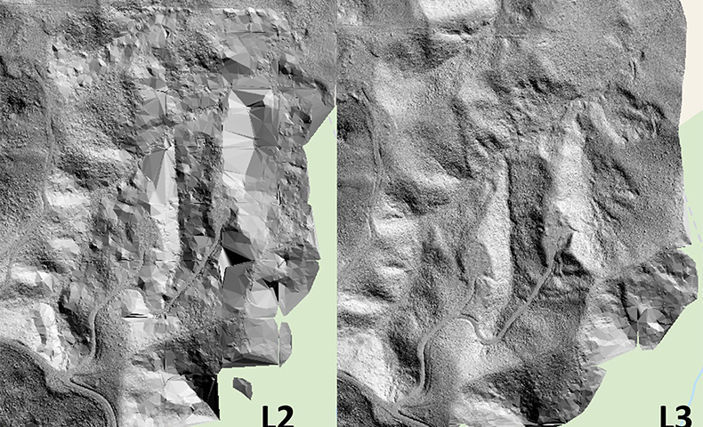
The Flight Area
The collaborative flight took place over a young pinus radiata stand in New Zealand, as shown below.

Forest Stand Surveyed
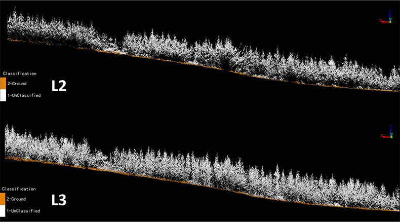
LiDAR Pulse Density, Point Density, and Flight Coverage
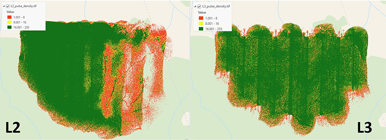
When flown using identical flight parameters, clear differences were observed between the DJI L2 and L3 sensors in terms of pulse density consistency, point cloud uniformity, and overall coverage quality. In areas of variable terrain, particularly where elevation changes were rapid or slopes were steep, the L2 sensor exhibited inconsistent pulse distribution. This resulted in localized reductions in point density and, in some cases, incomplete coverage across complex terrain features.
These inconsistencies were most apparent in areas where terrain variability increased the effective range between sensor and ground surface. Under these conditions, the L2 struggled to maintain uniform pulse density, leading to uneven point spacing and reduced data fidelity in sections of the point cloud. Such variability can introduce challenges during downstream processing, including surface modelling and feature extraction, where uniform data density is critical. Showing the L2 does not perform well in these conditions at 120m above ground level.

Top view of the resulting colourised datasets from the DJI Zenmuse L2 vs DJI Zenmuse L3 LiDAR sensors
| LiDAR Density Metrics | DJI Zenmuse L2 | DJI Zenmuse L3 |
|---|---|---|
| Pulses / m2 | 106 | 46 |
| Return / m2 | 112 | 278 |
| Spacing – all returns | 0.09m | 0.06m |
| Spacing – last returns | 0.1m | 0.15m |
In contrast, the DJI L3 demonstrated a markedly more stable and consistent performance across the same flight conditions. The L3 produced a uniform pulse emission pattern and maintained consistent point density throughout the survey area, regardless of terrain complexity. The resulting point cloud showed even spatial distribution, with minimal variation in density across ridgelines, slopes, and valley floors.
This consistency in pulse and point density translates directly into improved flight coverage reliability. The L3 effectively mitigated the effects of terrain-induced range variation, ensuring that data quality remained stable without requiring adjustments to flight altitude, overlap, or speed. As a result, the L3 enables more predictable mission planning and reduces the likelihood of data gaps that would otherwise necessitate re-flights or supplementary data acquisition. Something that has been a common attribute for drone-based LiDAR systems up until now.
Pulse Density comparison of the DJI Zenmuse L2 vs DJI Zenmuse L3 LiDAR sensors
From an operational standpoint, the improved pulse and point density consistency of the L3 enhances confidence in the completeness and accuracy of LiDAR-derived products. Uniform coverage supports higher-quality digital terrain and surface models, reduces the need for aggressive interpolation, and improves the reliability of quantitative analyses. In comparison, datasets acquired with the L2 in complex terrain may require additional quality control and post-processing to address density variability.
Overall, while both sensors were deployed under identical flight parameters, the L3 delivered superior performance in maintaining consistent pulse density and point cloud coverage across varied terrain, reinforcing its suitability for projects involving complex topography and demanding data quality requirements.
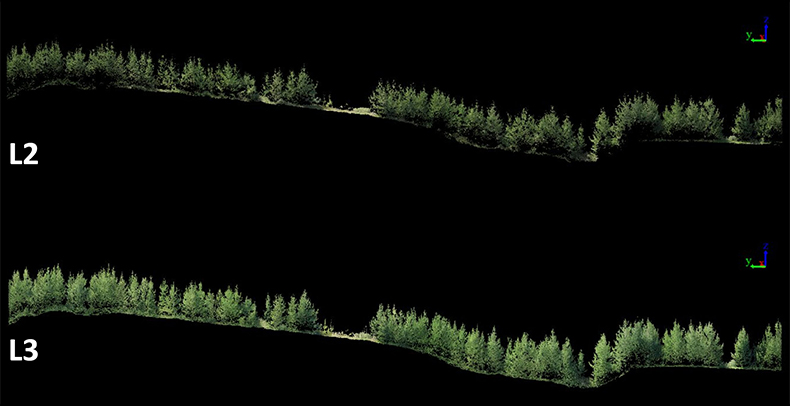
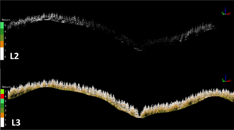
3m wide Profile comparison of the DJI Zenmuse L2 vs DJI Zenmuse L3 LiDAR sensors
Video of the DJI Zenmuse L3 LiDAR Sensor Resulting Point Cloud
Vegetation Penetration and Ground Classification Performance
Analysis of the digital terrain models (DTMs) derived from the DJI L2 and L3 LiDAR sensors highlights clear differences in performance under vegetated conditions. In areas of moderate to dense vegetation, the L2 sensor demonstrated limitations in its ability to consistently penetrate the canopy and return sufficient ground-level measurements. This resulted in intermittent gaps or inaccuracies in ground classification, particularly where understory density and complex canopy structures reduced the likelihood of ground returns.
By contrast, the DJI L3 sensor exhibited significantly improved vegetation penetration capabilities. The L3 consistently achieved reliable ground detection across the full range of site conditions, from densely vegetated stands to areas characterised by steep and complex terrain. Ground classification remained stable throughout the dataset, producing a more continuous and accurate digital terrain model without the need for extensive post-processing or manual intervention.
DJI Zenmuse L2 poor penetration of tree canopy in varied terrain resulted in typical “tenting” of the digital terrain model. The DJI Zenmuse L3 resolved the terrain with ease.
The improved performance of the L3 can be attributed to its enhanced LiDAR system design, which delivers higher point density and more effective multi-return capture. These characteristics increase the probability of laser pulses reaching the ground surface, even beneath dense canopy cover. As a result, the L3 provides a more robust representation of the underlying terrain, particularly in environments where vegetation structure and topography present challenges for lower-powered or lower-density systems.
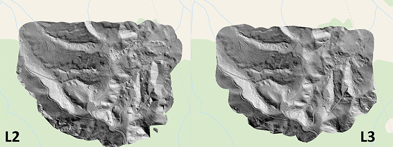
Comparison of ground classification through the tree canopy, DJI Zenmuse L2 vs DJI Zenmuse L3 LiDAR sensors
From a practical perspective, this improvement has direct implications for operational efficiency and data quality. The L3 reduces the risk of incomplete terrain models in forested or scrub-covered areas and improves confidence in derived products such as contours, slope models, and hydrological analyses. In contrast, datasets collected with the L2 in similar environments may require additional filtering, interpolation, or supplementary ground control to achieve comparable results.
L2 had issues with resolving ground in some of the areas of the flight area. In these areas very little ground or vegetation data was usable. L3 remained consistent with dense point data throughout.
Overall, while the L2 remains suitable for applications with limited vegetation or simpler terrain, the L3 demonstrates clear advantages for projects requiring consistent ground classification across dense vegetation and complex landscapes.
Tree-Level Detail and Structural Representation
High‑quality tree‑level detail is fundamental to effective forest management and underpins the accuracy of forest inventory derived from drone‑based LiDAR systems. Attributes such as individual tree height, crown dimensions, stem form, and branching structure are directly influenced by the resolution and fidelity of the underlying point cloud.
Comparative analysis of the DJI L2 and L3 datasets demonstrates a substantial improvement in tree‑level representation when using the L3 sensor. The L2 captured overall canopy form and general stand structure; however, fine‑scale details within individual trees were often less distinct, particularly within mid‑canopy and lower crown zones. In these areas, point density and return penetration were insufficient to reliably resolve smaller structural elements.
In contrast, the DJI L3 produced a significantly more detailed and coherent representation of individual trees. The increased point density and improved return capture enabled clear visualisation of individual branch architecture, including primary and secondary branches within the canopy. This enhanced structural definition was consistent across the stand and remained evident even in areas of dense foliage.
The ability to resolve branch‑level detail has direct implications for forest inventory and management applications. Improved structural clarity supports more accurate segmentation of individual trees, enhanced crown delineation, and greater confidence in derived metrics such as crown volume, canopy density, and biomass estimation. It also improves the potential for advanced analyses, including assessments of tree health, structural complexity, and growth patterns.
Overall, the L3’s superior tree‑level detail represents a meaningful advancement for drone‑based forest LiDAR surveys. By providing a more complete and nuanced depiction of individual tree structure, the L3 enhances the reliability and analytical value of LiDAR‑derived forest inventory outputs compared with the L2.
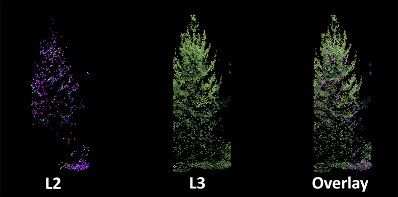
Individual Tree Level Detail from the DJI Zenmuse L2 vs DJI Zenmuse L3 LiDAR sensors
Take the Next Step with DJI Zenmuse L3 LiDAR
For organisations looking to invest in their own LiDAR surveying capability, Ferntech is New Zealand’s authorised distributor for DJI Enterprise solutions, while Interpine is an official DJI Enterprise reseller specialising in the forestry industry.
Both companies have experienced teams that can support the DJI Zenmuse L3 LiDAR payload and compatible aircraft platforms, providing everything required to get operational — including training, operational guidance, and practical support to ensure you are survey-ready from day one.
For forestry-specific workflows, Interpine offers specialised software solutions. Once you’ve captured high-quality L3 LiDAR data, you can begin extracting real value from your datasets using Interpine's TreeTools SilvaCloud Software — purpose-built for forestry analysis, inventory, and decision support.
Note: This article was originally written by the team at Interpine Innovation, who conducted the technical data analysis based on our collaborative flight test.
SPEAK WITH A SPECIALIST
Contact our team today to discuss the right solution for you.


