


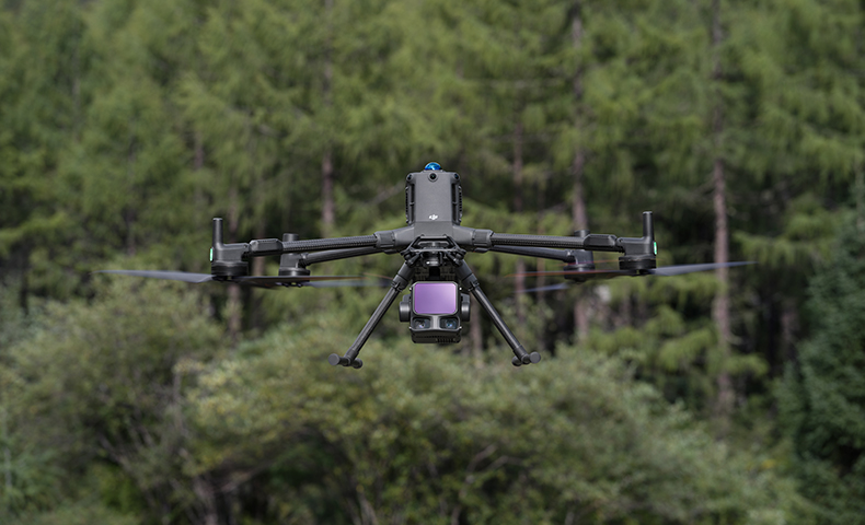
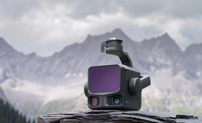
DJI Zenmuse L3 (LiDAR)
Includes 1 Year Care Enterprise Plus
High-precision LiDAR and RGB imaging for fast, accurate 3D mapping. The DJI Zenmuse L3 delivers exceptional detail and efficiency for surveying, forestry, and infrastructure.
The Zenmuse L3 features a 1535 nm long-range LiDAR, dual 100 MP cameras, and a precision IMU for fast and highly accurate 3D data capture. With DJI Terra support, you get a complete end-to-end workflow for reliable point cloud generation and advanced processing.
Key Features
Integrated Long-Range LiDAR Solution
Supported by next-gen hardware, L3 enables precise scans over extended ranges with faster point-cloud acquisition. Operators can preview, playback, and process point-cloud models on-site with DJI Pilot 2 and generate Task Quality Reports in DJI Terra for a streamlined, one-stop workflow.[A][B]
High Accuracy: At 120 m flight altitude, typical system accuracy is 3 cm vertical and 4 cm horizontal (RMSE). At 300 m, 5 cm vertical and 7.5 cm horizontal (RMSE).[C]
Exceptional Range: Detects up to 950 m @ 10% reflectivity (100 kHz) and up to 2000 m @ 80% reflectivity (100 kHz).[C]
Efficient Workflows: Deep integration with DJI Pilot 2 and DJI Terra simplifies planning, capture, QA and post-processing.[A][B]
1535 nm LiDAR with Flexible Scanning
Extended Detection: Up to 950 m @ 10% reflectivity (100 kHz) and 700 m @ 10% reflectivity (350 kHz) under typical test conditions.[C]
Up to 16 Returns: Capture more ground points under canopy and complex structures to improve terrain models and asset detail.[C]
Multiple Pulse Rates: 100/350/1000/2000 kHz settings help balance altitude, density and coverage for each mission.[C]
Scanning Modes: Linear (H 80°/V 3°), Star-Shaped (H 80°/V 80°), and Non-Repetitive (H 80°/V 80°) to match mapping, utilities, forestry and complex-structure needs.[C]
High-Precision POS/IMU System
The high-precision POS/IMU system fuses with RTK during post-processing to deliver accurate absolute position, speed and attitude, improving reliability and precision across environments.[A][C]
Dual 100 MP RGB Mapping Cameras
Dual 4/3 CMOS, 100 MP (with 25 MP mode), mechanical shutter and a combined horizontal FOV of 107° deliver rich true-colour point-cloud colouring and efficient image capture for mapping and inspection.[C]
Enhanced Operational Experience
Route Types: Waypoint, Area and Linear.
Point Cloud LiveView: RGB / Point Cloud / Side-by-Side, with real-time colouring options (Reflectivity, Height, Distance, RGB).
Model Playback & Merge: Review 3D point-cloud models on device and merge multiple flights for on-site QA.
Task Quality Reports: Auto-generated after collection in DJI Pilot 2; detailed processing and QA in DJI Terra.[A][B]
Application Scenarios
With DJI Matrice 400 and DJI Terra, Zenmuse L3 is ideal for land surveying & mapping, electricity transmission, forestry, mining, infrastructure management, and more.[A][B]
Selected Specifications
- Laser: 1535 nm; beam divergence 0.25 mrad; min effective distance 10 m[C]
- Detection Range (10% reflectivity): 700 m (350 kHz), 950 m (100 kHz); up to 2000 m @ 80% (100 kHz)[C]
- System Accuracy (RMSE): 3 cm V / 4 cm H @120 m; 5 cm V / 7.5 cm H @300 m[C]
- Returns: up to 16 (at 100/350 kHz); up to 8 (1000 kHz); 4 (2000 kHz)[C]
- RGB Cameras: Dual 100 MP (mechanical shutter), combined H-FOV 107°; 3 cm GSD @300 m[C]
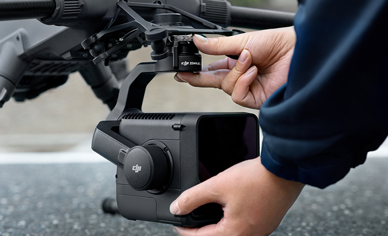
- Supported Aircraft: DJI Matrice 400 (with L3 single gimbal connector)[C]
- Ingress Protection: IP54 Operating Temp: −20 to 50 °C[C]
Product Specifications
System Specifications
Point Cloud System Accuracy: At 120m Flight Altitude:
Vertical Accuracy: 3 cm (RMSE)
Horizontal Accuracy: 4 cm (RMSE)
At 300m Flight Altitude:
Vertical Accuracy 5 cm (RMSE)
Horizontal Accuracy: 7.5 cm (RMSE)
Measured under the following conditions in a DJI laboratory environment:
1. The field contained objects with obvious angular features. DJI Matrice 400 was linked to a position-calibrated D-RTK 3 Multifunctional Station. The flight route was planned using DJI Pilot 2's Area Route (with Calibrate IMU enabled) with Linear scanning. The flight speed was set to 15 m/s, gimbal pitch to -90°, and each straight segment of the flight route was less than 3300 m.
2. Using exposed hard ground checkpoints that conformed to the diffuse reflection model.
3. DJI Terra was used for post-processing with Optimize Point Cloud Accuracy enabled.
Point Cloud Thickness: 1.2 cm@1σ (120m nadir flight altitude)
2 cm@1σ (300m nadir flight altitude)
Measured in Linear scanning mode, using check points on 80% reflectivity objects, with neither point cloud optimization nor downsampling enabled in DJI Terra. For 6σ, multiply the listed thickness by 6.
Combined Horizontal FOV (Dual RGB Mapping Cameras): 107°
Composed by merging images from two cameras with a 45° optical axis angle between them.
RGB Ground Sampling Distance (GSD): Average Value: 3 cm (300m nadir flight altitude)
For detailed calculation methods, refer to the user manual available on the Downloads page of the official DJI Zenmuse L3 webpage.
Weight: 1.60 kg (without single gimbal connector)
The Zenmuse L3 single gimbal connector weighs 145 g.
Dimensions: 192×162×202 mm (L×W×H)
Measured in the default stabilized state after power-on with non-orthogonal gimbal design.
Power: 64 W (typical)
100 W (max)
Supported Aircraft: DJI Matrice 400 (requires the Zenmuse L3 single gimbal connector)
Ingress Protection Rating: IP54
Operating Temperature: -20° to 50° C (-4° to 122° F)
Storage Temperature: -40° to 70° C (-40° to 158° F)
LiDAR
Laser Wavelength: 1535 nm
Laser Beam Divergence: 0.25 mrad (1/e²)
Laser Spot Size: Φ 41 mm@120 m (1/e²)
Φ 86 mm@300 m (1/e²)
Detection Range: 700 m@10% reflectivity, 350 kHz
950 m@10% reflectivity, 100 kHz
2000 m@80% reflectivity, 100 kHz
1. Range Definition: The range is defined as the distance at which 50% of the emitted laser pulses are detected. If a laser beam hits more than one subject, the total laser transmitter power is split and the achievable range is reduced.
2. Test Conditions: 100 klx ambient light, within the central area of the FOV, using a flat subject with a size larger than the laser beam diameter, a perpendicular angle of incidence, and an atmospheric visibility of 23 km.
3. The maximum detection range is 900 m by default. For a longer range, contact DJI support or an authorized dealer.
Wire Detection Range: 21.6mm Steel Core Aluminum Stranded Wire:
300 m@100 klx, 350 kHz
18.4mm Black PVC Insulated Wire:
100 m@100 klx, 350 kHz
1. Range Definition: The distance at which a fully scanned section of wire in mapping achieves a point density of 4 points per meter.
2. Test Conditions: 100 klx ambient light, 23km atmospheric visibility, LiDAR center FOV perpendicular to the wire, Non-Repetitive scanning mode, drone flying along the wire at 15 m/s, and the wire is clean and not aged.
Ranging Accuracy: Absolute Accuracy: ±10 mm
Repeatability: < 5 mm (1σ)
The above specifications can be met under test conditions of 25° C (77° F) ambient temperature, 350 kHz pulse rate, 80% object reflectivity, and distances of 120 m and 300 m. The actual environment may differ from the testing environment. The figure listed is for reference only.
Minimum Effective Detection Distance: 10 m
Ranging Resolution: 0.8 m
Laser Pulse Emission Frequency: 100 kHz, recommended flight altitude < 500 m
350 kHz, recommended flight altitude < 300 m
1000 kHz, recommended flight altitude < 100 m
2000 kHz, recommended flight altitude < 50 m
Number of Returns: 4, 8, 16 returns (100 kHz, 350 kHz)
4, 8 returns (1000 kHz)
4 returns (2000 kHz)
Cross-Cycle Calculation: 7 times
Scanning Mode and FOV: Linear Scanning Mode: Horizontal 80°, vertical 3°
Star-Shaped Scanning Mode: Horizontal 80°, vertical 80°
Non-Repetitive Scanning Mode: Horizontal 80°, vertical 80°
Laser Safety Classification: Class 1 (IEC 60825-1:2014)
RGB Mapping Camera
Sensor: 4/3 CMOS
Lens: Equivalent Focal Length: 28 mm
FOV: 73.3° (diagonal), 62° (horizontal), 41.2° (vertical)
Aperture: f/2.0-f/11
Shutter: Mechanical Shutter: 2-1/1500 s (f/2.0), 2-1/2000 s (f/2.8-f/11)
Shutter Count: 500,000
Electronic Shutter: 2-1/16000 s
Photo Size: 100 MP: 12288×8192
25 MP: 6144×4096
Minimum Photo Interval: JPEG:
25 MP: 0.5 s
100 MP: 1 s
RAW or JPEG + RAW:
1.2 s
Video Specification: Video Format: MP4 (MPEG-4 HEVC/H.265)
Resolution:
4K: 3840×2160@30fps
FHD: 1920×1080@30fps
Position and Orientation System (POS) System
GNSS Update Rate: 5 Hz
POS Update Rate: 200 Hz
Attitude Error: Yaw Angle: 0.02° (post-processed, 1σ)
Pitch/Roll Angle: 0.01° (post-processed, 1σ)
Positioning Accuracy: Horizontal Accuracy: 1.0 cm + 1 ppm (RTK fix)
Vertical Accuracy: 1.5 cm + 1 ppm (RTK fix)
Supported PPK Differential Data Formats: DAT: Generated in Base Station Mode by D-RTK 3 Multifunctional Station and D-RTK 2
RINEX: v2.1x, v3.0x
RTCM: v3.0, v3.1, v3.2, v3.3 (protocols: MSM3, MSM4, MSM5, MSM6, MSM7)
OEM: OEM4, OEM6
For field operation, ensure the distance between the Multifunctional Station and the aircraft does not exceed 15 km, and the Multifunctional Station supports satellite observation with more than two GNSS constellations.
Gimbal
Degrees of Freedom: 3-axis (pitch, roll, yaw)
Angular Accuracy: ±0.01°
Mechanical Range: Pitch: -135° to +73°
Roll: -90° to +60°
Yaw: -105° to +105°
Structural limit, not controllable range.
Controllable Range: Pitch: -120° to +60°
Yaw: -80° to +80°
Roll is uncontrollable, for stabilization only.
Self-Check Method: Roll Axis: Self-check not required
Yaw Axis: Checks using limit stop
Pitch Axis: Self-check not required
Mounting Method: Detachable DJI SKYPORT (Zenmuse L3 single gimbal connector)
Data Storage
Raw Data Storage: Photo/IMU/Point cloud/GNSS/Calibration files
Standard Memory Card: CFexpress™ Type B Memory Card, sequential write speed 1500 MB/s
Standard Card Reader: Read/write speed > 900 MB/s
Software Ecosystem
Data Collection: DJI Pilot 2
Data Processing: DJI Terra
Data Application: DJI Modify
Cloud Application: DJI FlightHub 2
Data Format: DJI Terra supports exporting point cloud models in the following formats:
Standard Point Cloud Format: PNTS/LAS/LAZ/PLY/PCD/S3MB
DJI Modify supports importing point cloud models in the following formats:
Standard Point Cloud Format: LAS
In the box
Zenmuse L3 × 1
Zenmuse L3 Lens Cap × 1
CFexpress™ Type B Memory Card (1 TB) (brand may vary; actual product received prevails) × 2
CFexpress™ Type B Card Reader × 1
Zenmuse L3 Storage Case × 1
Lens Cleaning Cloth × 1
DJI Matrice 400 Carrying Case Insert (Zenmuse L3)× 1
Zenmuse L3 Single Gimbal Connector × 1
Screws and Tools× 1
Zenmuse L3 Gimbal Damper (4 pcs) × 1
DJl Care Enterprise Plus (L3) NZ × 1
WHY BUY FROM US?
By buying from Ferntech, you'll have the confidence that you are dealing directly with New Zealand's leading drone experts. Our staff are knowledgable drone pilots who offer expert advice, trusted support and superior specialist service. Only through us will you receive a full New Zealand warranty, phone and email support, and access to our certified Repairs Centre with DJI-qualified drone technicians. And we guarantee that we will have the best prices on the market — if not let us know and we will match any price (conditions apply).
Warranty Details
System Performance
What aircraft is Zenmuse L3 compatible with? Which gimbal interface can it be mounted on?
Compatible with DJI Matrice 400, and requires the use of the Zenmuse L3 single gimbal connector. Please ensure that the gimbal connector is connected to the E1 port on the aircraft's underside. Otherwise mapping accuracy will be reduced.
What is the protection level of Zenmuse L3?
Zenmuse L3 can achieve an IP54 rating according to the IEC60529 standard under controlled laboratory conditions. To ensure the highest levels of protection:
1. Before installing, make sure that the interface and surface of the gimbal are dry;
2. Before use, make sure that the gimbal is firmly installed on the drone and the CFexpress™ card protective cap is clean, free of foreign objects, and closed;
3. Before opening the CFexpress™ card protective cap, wipe the surface of the drone clean.
4. The protection level will decrease over time due to normal device use and wear.
What is the laser pulse emission frequency of Zenmuse L3? How many returns does it support?
4, 8, 16 returns (100 kHz, 350 kHz)
4, 8 returns (1000 kHz)
4 returns (2000 kHz)
How does the range of Zenmuse L3 change at different laser pulse emission frequencies?
290 m (center), 200 m (edge)@10% reflectivity, 2000 kHz, recommended operating altitude ≤ 50 m
400 m (center), 280 m (edge)@10% reflectivity, 1000 kHz, recommended operating altitude ≤ 100 m
700 m (center), 500 m (edge)@10% reflectivity, 350 kHz, recommended operating altitude ≤ 300 m
950 m (center), 650 m (edge)@10% reflectivity, 100 kHz, recommended operating altitude ≤ 500 m
1. Range Definition: The range is defined as the distance at which 50% of the emitted laser pulses are detected. If a laser beam hits more than one subject, the total laser transmitter power is split and the achievable range is reduced.
2. Test Conditions: 100 klx ambient light, within the central area of the FOV, using a flat subject with a size larger than the laser beam diameter, a perpendicular angle of incidence, and an atmospheric visibility of 23 km.
3. The maximum detection range is 900 m by default. For a longer range, contact DJI support or an authorized dealer.
How many scanning modes does Zenmuse L3 have? In what scenarios do they apply?
Supports Linear, Star-Shaped, and Non-Repetitive scanning modes for different operational scenarios:
1. Linear: Achieves more consistent point cloud distribution, ideal for high-accuracy terrain mapping.
2. Star-Shaped: Balances accuracy with multiple scan angles and penetration capability, well-suited for forests or dense urban environments.
3. Non-Repetitive: Provides multiple scan angles and broader coverage, optimized for transmission tower reconstruction and other complex structural surveys.
What improvements does Zenmuse L3 have compared to the previous generation?
Hardware performance improvements:
1. Zenmuse L3 delivers enhanced LiDAR performance. When measured at the same distance, Zenmuse L3 produces a laser spot about one-fifth the size of L2 and supports up to 16 returns. This means much stronger penetration capability, greater range, and higher ranging accuracy.
2. The new dual 100MP RGB mapping camera system brings a horizontal FOV of up to 107°, compared to L2's 73.7°.
3. POS accuracy is improved to 0.02° for heading, and 0.01° for roll and pitch.
Accuracy and efficiency improvements:
Zenmuse L3's vertical accuracy is better than 3 cm at 120m altitude, better than 5 cm at 300 m, and better than 10 cm at 500 m. The point cloud thickness produced by Zenmuse L3 is only half that of Zenmuse L2, supporting advanced analysis and high-accuracy applications.
With a smaller laser spot and higher single-pulse energy, Zenmuse L3 offers superior penetration capability. In terrain mapping and similar applications, it captures more ground points with greater completeness, significantly improving the accuracy and integrity of terrain data for precise surface fitting and reconstruction.
When mounted on DJI Matrice 400, Zenmuse L3 delivers outstanding efficiency. At a flight altitude of 300 m, a single flight can cover up to 10 km², enabling up to 100 km² of daily coverage.
What is the dual 100MP RGB mapping camera system for?
The dual RGB mapping camera system expands the horizontal FOV to 107°, enabling each acquisition to cover a broader area. Even with a 20% LiDAR side overlap ratio, you can capture data for both digital orthophoto maps (DOM) and digital elevation models (DEM) in a single flight, thereby greatly improving operational efficiency.
What type of CFexpress™ memory card does Zenmuse L3 require? What if I use a non-bundled card?
It is recommended to use the CFexpress™ Type B memory card (1 TB) that comes with Zenmuse L3. This card is specifically optimized for the unique storage requirements of L3's point cloud data, images, and calibration files, ensuring ideal write speed, power efficiency, and file management.
Using a non-bundled CFexpress™ card may result in lower write speed or less efficient power management, which could lead to frame drops during operational file storage, thus affecting the accuracy of the results. When a non-bundled card is inserted, the app will display a warning message.
Why do the left and right images in the Zenmuse L3 dual 100MP RGB camera Liveview sometimes appear with different brightness levels?
To ensure consistent exposure in the final images, each camera uses center-weighted metering to optimize resolution. If the left and right cameras capture scenes with significantly different ambient lighting, there will be visible brightness differences in the Liveview display.
Why do I see a stitching seam in the Zenmuse L3 dual 100MP RGB camera Liveview under certain conditions?
It is recommended to keep a distance of at least 20 m between L3 and the ground/subjects. If the distance is too close, the left and right cameras may capture significantly different perspectives of the scene, resulting in visible seams in the Liveview.
What is the difference between 100MP and 25MP operation? Which scenarios are each suitable for?
100MP (High Resolution): Provides more pixels and finer image detail, though it requires more storage space. At the same ground sample distance (GSD), it allows for higher flight altitudes and is recommended for operations above 150 m.
25MP (High Sensitivity): Features larger equivalent pixel size, better signal-to-noise ratio, and higher sensitivity. It requires less storage and, for the same GSD, necessitates lower flight altitudes, making it ideal for operations at or below 150 m.
Does the Zenmuse L3 single gimbal connector support other DJI Enterprise payloads?
The Zenmuse L3 single gimbal connector currently only supports L3. Mounting other aerial mapping payloads may result in reduced mapping accuracy. For example, if Zenmuse H30T is mounted, video footage may experience minor shaking, which can affect advanced functions such as Smart Track, Automated Overhead Power Line Inspection, and others.
When Zenmuse L3 is shooting video, why doesn't the gimbal recenter, and which RGB camera is used for recording?
During video recording, only one camera is active. Specifically, when recording video, the right-side RGB camera (when facing the LiDAR) is used.
Field Data Collection
How efficient is the surveying and mapping operation of Zenmuse L3? How is it calculated?
Zenmuse L3 can collect data covering an area of up to 10 km² in a single flight, enabling up to 100 km² of mapping per day.
When paired with DJI Matrice 400, Zenmuse L3 can achieve a daily mapping coverage of up to 100 km² (flat terrain, 300m nadir flight altitude, 20% side overlap, 17m/s flight speed, and a total effective flight time of 6 hours).
What is the typical flight altitude for Zenmuse L3? What is the corresponding accuracy?
At 120m Flight Altitude:
Vertical Accuracy: 3 cm (RMSE)
Horizontal Accuracy: 4 cm (RMSE)
At 150m Flight Altitude:
Vertical Accuracy: 3.5 cm (RMSE)
Horizontal Accuracy: 5 cm (RMSE)
At 300m Flight Altitude:
Vertical Accuracy 5 cm(RMSE)
Horizontal Accuracy: 7.5 cm (RMSE)
Measured under the following conditions in a DJI laboratory environment:
1. The field contained objects with obvious angular features. DJI Matrice 400 was linked to a position-calibrated D-RTK 3 Multifunctional Station. The flight route was planned using DJI Pilot 2's Area Route (with Calibrate IMU enabled) with Linear scanning. The flight speed was set to 15 m/s, gimbal pitch to -90°, and each straight segment of the flight route was less than 3300 m.
2. Using exposed hard ground checkpoints that conformed to the diffuse reflection model.
3. DJI Terra was used for post-processing with Optimize Point Cloud Accuracy enabled.
What improvements does Zenmuse L3 offer in Power Line Follow compared to the previous generation?
1. The FOV has been increased to 80°×80°, which allows a larger section of power lines to be detected at the same altitude.
2. The smaller laser spot and extended detection range make power line detection more stable and reliable.
3. Power Line Follow now supports higher operational altitudes: for transmission lines, 10 to 130 m (recommended: 50 to 80 m); for distribution lines, 10 to 50 m (recommended: 30 to 50 m). With higher altitudes, the drone can fly directly over crossing lines without detours, greatly improving flight efficiency.
What types of lines is the Zenmuse L3's Power Line Follow feature suitable for?
The Power Line Follow feature of Zenmuse L3 is designed for transmission and distribution lines with voltage levels of 10 kV and above. However, it cannot guarantee effective recognition for low-voltage lines, such as those at 400 V, or communication and broadcasting cables.
In what scenarios could the identification and tracking performance of power lines be affected? How can these issues be resolved?
The performance of power line recognition and following may be compromised under the following scenarios:
1. Insulated lines;
2. Tree canopies that are too close to or even obstructing the lines;
3. Dense distribution of multiple power lines, such as in substation entry and exit lines;
4. Complex intersections between power lines and other cables.
Solutions:
When encountering junctions with dense or multiple crossing lines, the system may issue a warning. In these situations, switch to manual flight to pass through the area.
In areas where tree canopies are very close to the wires, or where there are black PVC-insulated wires under the canopies, it is recommended not to use Power Line Follow.
Is it necessary to perform IMU calibrations during a Power Line Follow task?
There is no need to specifically perform IMU calibrations during Power Line Follow tasks, as the acceleration and deceleration movements of the drone platform while passing towers can also serve as IMU calibrations to some extent.
How to use Zenmuse L3's real-time point cloud data? Is it possible to subscribe to and parse data streams?
1. Real-time point cloud data stream subscription: When recording point cloud, Zenmuse L3 supports subscribing to real-time point cloud data streams via OSDK/PSDK devices. For details on the data parsing protocol, refer to the SDK developer documentation available on the DJI Developer webpage.
2. Offline export of real-time point cloud data: After point cloud recording is complete, Zenmuse L3 saves a copy of the real-time point cloud data stream. These files, with the .ldrt extension, can be found in the media directory of the memory card for the corresponding flight. For details on file format, refer to the Zenmuse L3 User Manual available in the Downloads section in the navigation bar of this page.
Does Zenmuse L3's real-time point cloud data support cloud sharing?
Yes. After the operation, you can select real-time point cloud results in DJI Pilot 2 and upload them to the relevant project in DJI FlightHub 2 for emergency decision-making.
Is the accuracy of Zenmuse L3's real-time point cloud data consistent with the point cloud generated by DJI Terra?
No. The real-time point cloud from Zenmuse L3 is intended only for field operation preview, and its accuracy is not guaranteed. For high-accuracy applications, you should use DJI Terra for offline point cloud reconstruction.
How do I measure the real-time point cloud from Zenmuse L3?
After point cloud recording is complete, you can playback point cloud preview on DJI Pilot 2 and use measurement tools to measure location, distance, and area.
When DJI Matrice 400 is equipped with Zenmuse L3, what is the supported altitude for Real-Time Follow?
DJI Matrice 400 supports Real-Time Follow at altitudes from 30 to 300 m.
Which types of flight tasks and flying modes does Zenmuse L3 support?
It supports Waypoint Route, Area Route, and Linear Route. For flying modes, it supports Terrain Follow and Power Line Follow.
What is the function of Zenmuse L3's Point Cloud Result Preview?
When editing a flight route in DJI Pilot 2, users can preview estimated point cloud results in real time based on parameters such as flight altitude, flight speed, side overlap ratio, scanning mode, pulse rate, and object reflectivity. The preview shows outputs including the Flight Band Center Scatter Plot, Adjacent Flight Band Center Scatter Plot, and Min Density Scatter Plot.
Post-processing
How does Zenmuse L3 calibrate itself, and when is calibration necessary?
When Zenmuse L3 exhibits issues such as rule-based coloring errors or point cloud layering, it is recommended to use DJI Terra to perform LiDAR calibration. For detailed instructions, refer to the Zenmuse L3 User Manual available in the Downloads section in the navigation bar of this page.
How do I use DJI Terra's PPK function? Which satellite observation data formats are supported?
DJI Terra V5.1.0 and later versions support PPK. Local PPK accepts the following satellite observation data formats:
DAT: Generated in Base Station Mode by D-RTK 3 Multifunctional Station and D-RTK 2
RINEX: v2.1x, v3.0x
RTCM: v3.0, v3.1, v3.2, v3.3 (protocols: MSM3, MSM4, MSM5, MSM6, MSM7)
OEM: OEM4, OEM6
For field operation, ensure the distance between the Multifunctional Station and the aircraft does not exceed 15 km, and the Multifunctional Station supports satellite observation with more than two GNSS constellations.
Is a license required to use DJI Terra for processing Zenmuse L3's point cloud data?
Point cloud processing for Zenmuse L3 is a free feature in DJI Terra. Advanced functions, such as point cloud accuracy optimization and generating other deliverables, are also free of charge.
This pricing information is based on DJI Terra V5.1.0. Whether subsequent updated functions will be charged is subject to the release notes at the time of publication.
There's currently no reviews for this product, be the first to write one.
Related Products


$1,200.00

Contact for Pricing


