


DJI Mavic 3 Multispectral (Rental)
The DJI Mavic 3 Multispectral is designed for precision agriculture and environmental monitoring.
Features
New standard for portable multispectral drones
The DJI Mavic 3 Multispectral is designed for precision agriculture and environmental monitoring.
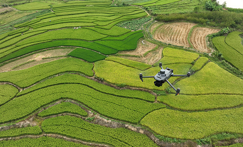
It is equipped with a multispectral imaging system that quickly captures crop growth information to achieve more effective crop production.
The Mavic 3M includes an RTK module that achieves centimetre-level positioning.
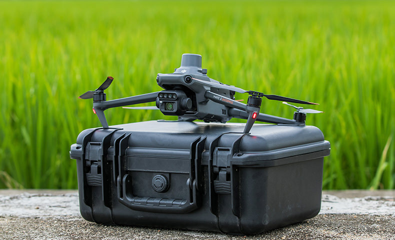
The Mavic 3 Multispectral is a highly-portable drone: It's foldable design and 951g weight means it can be carried in a bag to enable farmers to carry out operations at anytime.
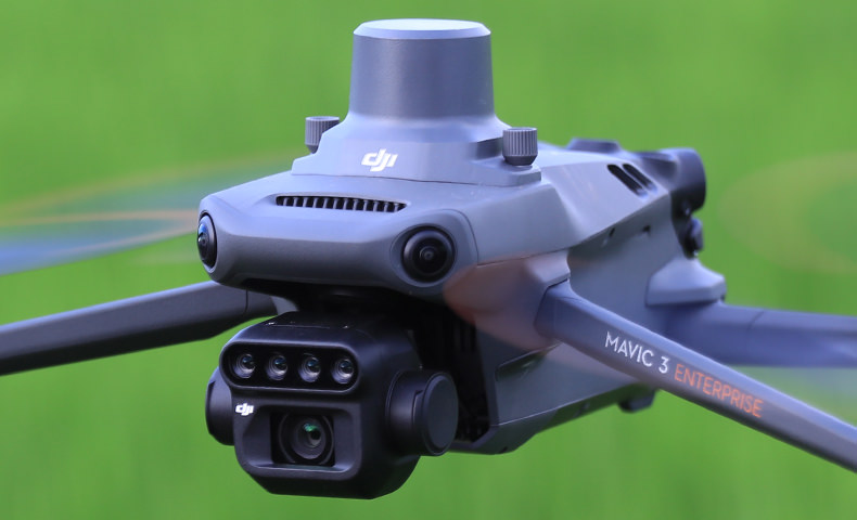
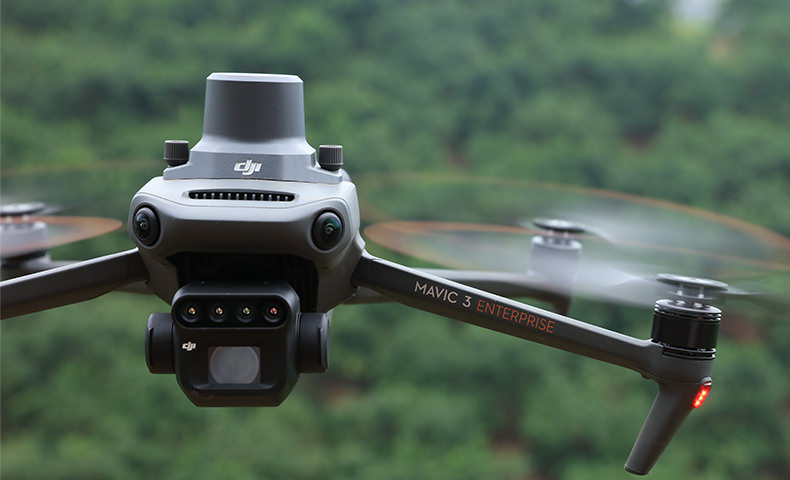
Mavic 3M Cameras
The DJI Mavic 3M has a newly-upgraded imaging system with one 20MP RGB camera and four 5MP multispectral cameras. This enables applications such as high-precision aerial surveying, crop growth monitoring, and natural resource surveys.
It has 43 minutes of flight time and can complete the surveying and mapping operations of an area as vast as 2 square kilometers in a single flight.
Multispectral Cameras
The Mavic 3M has four 5MP multispectral cameras. Infact, the Mavic 3M is the world’s smallest 4-band multispectral drone camera.
Its built-in camera array combines Green, Red, Red Edge, and Near Infrared sensors.
- Near Infrared: 860 nm ± 26 nm
- Red: 650 nm ± 16 nm
- Red Edge: 730 nm ± 16 nm
- Green: 560nm ± 16 nm
These sensors support the NDVI, GNDVI, and NDRE vegetation indexes to provide farmers with vital information.
- NDVI: Makes it possible to detect plants under stress, differentiate between crops, and determine at which stage they are in their growing cycle.
- NDRE: Provides insights on chlorophyll content in leaves.
- GNDVI: Useful for estimating photosynthetic activity, as well as water and nitrogen content in the plant canopy.
RGB Camera
Beyond its multispectral capabilities, the Mavic 3M has a visual camera to empower agriculture and mapping workflows.
It features:
- 20MP wide camera; 4/3 CMOS
- Mechanical shutter (1/2000s fastest mechanical shutter speed)
- 0.7 second interval shooting - high-speed burst when RGB camera is used
- Large pixel size: 3.3μm pixels
- Improved low-light software
With these key features, the Mavic 3M is engineered for rapid aerial surveys and data quality.
These camera specs, together with the drone’s 43 minute maximum flight time, mean that the Mavic 3M can capture data across up to 2 square kilometers in a single flight.
Sunlight Sensor
The Mavic 3M has a built-in sunlight sensor that captures solar irradiance and records it in an image file, allowing for light compensation of image data during 2D reconstruction.
This results in more accurate NDVI results, as well as improved accuracy and consistency of data acquired over time.
RTK Module Included
The Mavic 3M comes with an RTK module, allowing agricultural professionals to conduct high-precision aerial surveys with care, efficiency and - crucially - without the need for Ground Control Points.
The RTK module enables centimeter-level positioning. Flight control, the camera, and the RTK module sync in microseconds to accurately capture the location of each camera's imaging centre.
Enhanced Safety Features
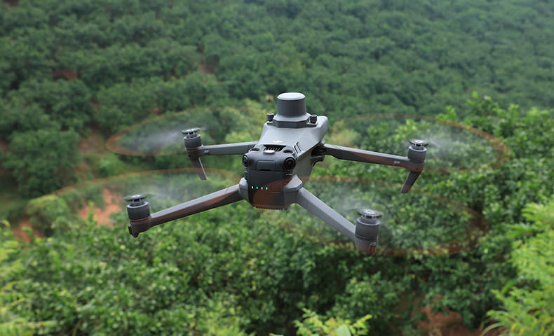
The Mavic 3M has an advanced suite of safety features.
Advanced Pilot Assistance System (APAS 5.0): State-of-the-art obstacle sensing and navigation. Data from six vision and two wide-angle sensors are assessed in real-time to detect obstacles in every direction and - when using Avoid mode - reroute your flight path accordingly.
Advanced Return To Home: This smart feature optimises your flight path to preserve battery and get your aircraft home safe and sound at the touch of a button.
AirSense: The built-in AirSense system provides an early warning of nearby crewed aircraft transmitting ADS-B signals.
O3 Transmission: The Mavic 3M comes with DJI’s O3 transmission technology. It sets the standard for video and control stability and provides a reliable link between pilot and aircraft. The Mavic 3M has a transmission range of 8km (CE).
The Mavic 3M comes with Enterprise Shield cover (Basic, 1 year).
Smart Terrain Follow
The Mavic 3M offers Terrain Follow, helping you maintain an even altitude as you fly a survey mission across varying terrain.
By smoothly adjusting according to the terrain, you can secure the integrity of your data while it’s gathered, without having to account for any differences in post-processing.
For situations when you weren't able to import a DSM or local elevation data pre-flight, the Mavic 3M's collision avoidance sensors can take over by detecting the ground below and automatically adjusting flight height accordingly.
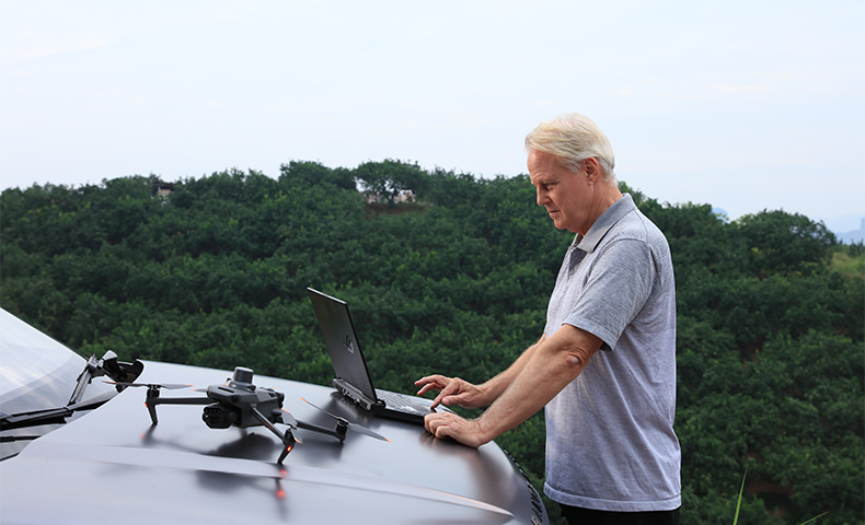
Intelligent Field Scouting
The Mavic 3M can carry out automatic field scouting. The field scout images can be uploaded to the DJI SmartFarm Platform in real time through a 4G network.
It can find abnormalities, such as emergence deficiencies, weed pressure, and crop lodging in a timely manner.
It can also conduct intelligent analyses, such as cotton seedling identification and rice production testing, using AI identification for real-time sharing of crop growth information, guidance of agronomic activities, and easy management of 70 hectares of farmland by one person.
Mavic 3E Customisation
Build a solution tailored to your needs with Cloud API and MSDK.
Cloud API
The Mavic 3M can be directly connected to a third-party cloud platform via Pilot 2's built-in DJI Cloud API based on the MQTT protocol. There is no need to develop an app separately to enable the transmission of UAV equipment information, live streaming, photo data, and other information.
MSDK
The Mavic 3M supports Mobile SDK 5 (MSDK5) with a fully open-source production code sample. The MSDK5 makes it possible to develop a proprietary control app for UAV field patrol, smart surveying, and other scenarios, making it more user-friendly.
Full Software Suite
The Mavic 3 Multispectral is fully compatible with the DJI SmartFarm app, allowing agriculture professionals to coordinate any data gathered with spraying and spreading operations.
SmartFarm comes with a range of features for streamlined workflows, including intuitive mission planning, a full fleet overview, field management, data assessment, and effortless collaboration between teams.
Data captured by Mavic 3M is also fully compatible with DJI Terra, so you can easily and efficiently create maps and models of your targets.
The Mavic 3M comes with a three-month DJI Terra Full licence (one device) and one-year access to the DJI SmartFarm Platform.
*Please note that the DJI Smart Agricultural Platform will be supported in Q2 of 2023.

Product Specifications
Aircraft
Net Weight (with propellers and RTK module) [1]
951 g
Max Takeoff Weight
1,050 g
Dimensions (Folded/Unfolded)
Folded (without propellers): 223×96.3×122.2 mm (Length×Width×Height)
Unfolded (without propellers): 347.5×283×139.6 mm (Length×Width×Height)
Diagonal Length
Diagonal: 380.1 mm
Max Ascent Speed
6 m/s (Normal Mode)
8 m/s (Sport Mode)
Max Descent Speed
6 m/s (Normal Mode)
6 m/s (Sport Mode)
Max Flight Speed (at sea level, no wind)
15 m/s (Normal Mode)
Flying forward: 21 m/s, flying sideways: 20 m/s, flying backwards: 19 m/s (Sport mode) [2]
Max Wind Speed Resistance
12 m/s [3]
Max Take-off Altitude Above Sea Level
6000 m (without a payload)
Max Flight Time (without wind)
43 minutes [4]
Max Hover Time (without wind)
37 minutes [4]
Max Flight Distance
32 km [6]
Max Tilt Angle
30° (Normal Mode)
35° (Sport Mode)
Max Angular Velocity
200°/s
GNSS
GPS + Galileo + BeiDou + GLONASS (GLONASS is supported only when RTK module is enabled)
Hovering Accuracy Range
Vertical: ±0.1 m (Vision Positioning enabled); ±0.5 m (GNSS Positioning enabled); ±0.1 m (D-RTK enabled)
Horizontal: ±0.3 m (Vision Positioning enabled); ±0.5 m (HD Positioning enabled); ±0.1 m (RTK enabled)
Operating Temperature
-10° to 40° C (14° to 104° F)
Internal Storage
N/A
Motor Model Number
2008
Propeller Model Number
9453F Enterprise Edition
Light Sensor
Built-in module
RGB Camera
Image Sensor
4/3 CMOS
Effective Pixels: 20 MP
Lens
FOV: 84°
Equivalent focal length: 24 mm
Aperture: f/2.8 to f/11
Focus: 1 m to ∞
ISO Range
100-6400
Shutter speed
Electronic shutter: 8-1/8000 s
Mechanical shutter: 8-1/2000 s
Max Image Size
5280×3956
Photo Shooting Mode
Single shot: 20 MP
Timelapse: 20 MP
JPEG: 0.7/1/2/3/5/7/10/15/20/30/60 s
JPEG + RAW: 3/5/7/10/15/20/30/60 s
Panorama: 20 MP (original material)
Video Resolution
H.264:
4K: 3840×2160@30fps
FHD: 1920×1080@30fps
Max Video Bitrate
4K: 130Mbps
FHD: 70Mbps
Supported File System
exFAT
Image Format
JPEG/DNG (RAW)
Video Format
MP4 (MPEG-4 AVC/H.264)
Multispectral Camera
Image Sensor
1/2.8-inch CMOS, effective pixels: 5 MP
Lens
FOV: 73.91° (61.2° x 48.10°)
Equivalent focal length: 25 mm
Aperture: f/2.0
Focus: Fixed Focus
Multispectral Camera Band
Green (G): 560 ± 16 nm;
Red (R): 650 ± 16 nm;
Red Edge (RE): 730 ± 16 nm;
Near infrared (NIR): 860 ± 26 nm;
Gain Range
1x-32x
Shutter Speed
Electronic Shutter: 1/30~1/12800 s
Max Image Size
2592×1944
Image Format
TIFF
Video Format
MP4 (MPEG-4 AVC/H.264)
Photo Shooting Mode
Single shot: 5 MP
Timelapse: 5 MP
TIFF: 2/3/5/7/10/15/20/30/60 s
Video Resolution
H.264
FHD: 1920 x 1080@30fps
Video content: NDVI/GNDVI/NDRE
Max Video Bitrate
Stream: 60 Mbps
Gimbal
Stabilization System
3-axis mechanical gimbal (tilt, roll, pan)
Mechanical Range
Tilt: -135° to 45°
Roll: -45° to 45°
Pan: -27° to 27°
Controllable Range
Tilt: -90° to 35°
Pan: Uncontrollable
Max Control Speed (tilt)
100°/s
Angular Vibration Range
±0.007°
Sensing System
Sensing System Type
Omnidirectional binocular vision system, with an infrared sensor at the bottom of the aircraft
Forward
Distance Measuring Range: 0.5 m to 20 m
Detection Range: 0.5 m to 200 m
Effective Obstacle Avoidance Speed: Flight Speed ≤15 m/s
FOV: Horizontal 90°, vertical 103°
Backward
Distance Measuring Range: 0.5 m to 16 m
Effective Obstacle Avoidance Speed: Flight speed ≤12 m/s
FOV: Horizontal 90°, vertical 103°
Lateral
Distance Measuring Range: 0.5 m to 25 m
Effective Obstacle Avoidance Speed: Flight speed ≤15 m/s
FOV: Horizontal 90°, vertical 85°
Upward
Distance Measuring Range: 0.2 m to 10 m
Effective Obstacle Avoidance Speed: Flight Speed ≤6 m/s
FOV: Front and rear 100°, left and right 90°
Downward
Distance Measuring Range: 0.3 m to 18 m
Effective Obstacle Avoidance Speed: Flight speed ≤6 m/s
FOV: Front and rear 130°, left and right 160°
Operating Environment
Front, Rear, Left, Right, Above: Surfaces with clear patterns and adequate lighting (> 15 lux, environments with normal indoor fluorescent light exposure)
Below: Surfaces with diffuse reflection material and a reflectivity of >20% (such as walls, trees, people, etc.); Adequate lighting (>15 lux, environments with normal indoor fluorescent light exposure)
Video Transmission
Video Transmission System
DJI O3 Image Transmission Industry Edition
Live View Quality
Remote Controller: 1080p/30fps
Operating Band [7]
2.400-2.4835 GHz
5.725-5.850 GHz
Max Effective Signal Distance (Unobstructed, No interference) [8]
FCC: 15 km
CE: 8 km
SRRC: 8 km
MIC: 8 km
Max Transmission Distance (Obstructed) [9]
Strong Interference (urban landscapes, residential areas, etc.): 1.5-3 km (FCC/CE/SRRC/MIC)
Medium Interference (suburban landscapes, city parks, etc.): 3-9 km (FCC), 3-6 km (CE/SRRC/MIC)
Weak Interference (remote fields, open farmland, etc.): 9-15 km (FCC), 6-8 km (CE/SRRC/MIC)
Max Download Speed
15 MB/s (with DJI RC Pro Industry Edition)
Latency (depending on environment and mobile device)
Approximately 200 milliseconds
Antennas
4 antennas, 2 transmitting and 4 receiving
Transmitter Power (EIRP)
2.4 GHz: <33 dBm (FCC), <20 dBm (CE/SRRC/MIC)
5.8 GHz: <33 dBm (FCC), <30 dBm (SRRC), <14 dBm (CE)
Other
Supports the DJI Cellular module
DJI RC Pro Enterprise Edition
Image Transmission System
DJI O3 Image Transmission Industry Edition
Max Effective Signal Distance (Unobstructed, No interference) [8]
FCC: 15 km
CE: 8 km
SRRC: 8 km
MIC: 8 km
Operating Band of Image Transmission [7]
2.400-2.4835 GHz
5.725-5.850 GHz
Antennas
4 antennas, 2 transmitting and 4 receiving
Operating Band of Image Transmission and Transmitter Power (EIRP)
2.4 GHz: <33 dBm (FCC); <20 dBm (CE/SRRC/MIC)
5.8 GHz: <33 dBm (FCC); <14 dBm (CE); <23 dBm (SRRC)
Wi-Fi Protocol
802.11 a/b/g/n/ac/ax
Support 2×2 MIMO Wi-Fi
Wi-Fi Operating Band [7]
2.400-2.4835 GHz
5.150-5.250 GHz
5.725-5.850 GHz
Wi-Fi Operating Band and Transmitter Power (EIRP)
2.4 GHz: <26 dBm (FCC); <20 dBm (CE/SRRC/MIC)
5.1 GHz: <26 dBm (FCC); <23 dBm (CE/SRRC/MIC)
5.8 GHz: <26 dBm (FCC/SRRC); <14 dBm (CE)
Bluetooth Protocol
Bluetooth 5.1
Bluetooth Operating Band
2.400-2.4835 GHz
Bluetooth Transmitter Power (EIRP)
<10 dBm
Screen Resolution
1920×1080
Screen Size
5.5 inches
Screen Frame Rate
60 fps
Screen Brightness
1,000 nits
Touch-Screen
10-point multi-touch
Battery
Lithium-ion battery (5000 mAh, 7.2 V)
Charging Type
100W Battery Charging Hub or USB charger with 12V or 15V specifications is recommended
Rated Power
12 Watts
Storage Capacity
Internal Memory (ROM): 64 GB
Supports microSD card usage to increase storage capacity
Charging Time
Approx. 1.5 hours (measured when only using the 100W Battery Charging Hub to charge the remote control, or when using a 15V USB charger)
Approximately 2 hours (measured using a 12V USB charger)
Approximately 2 hours and 50 minutes (measured using the 100W Battery Charging Hub to charge the aircraft and remote control at the same time)
Operating Time
Approx. 3 hours
Video Output Port
Mini-HDMI Port
Operating Temperature
-10° to 40° C (14° to 104°F)
Storage Temperature Range
<1 month: -30° to 60° C (-22° to 140° F)
One to three months: -30° to 45° C (-22° to 113° F)
Three to six months: -30° to 35° C (-22° to 95° F)
More than six months: -30° to 25° C (-22° to 77° F)
Charging Temperature
5° to 40° C (41° to 104° F)
Supported DJI Aircraft [10]
DJI Mavic 3E
DJI Mavic 3T
DJI Mavic 3M
GNSS
GPS + Galileo + GLONASS
Dimensions
Antenna is folded and no control sticks are installed:
183.27×137.41×47.6 mm (Length×Width×Height)
Antenna unfolded and control sticks are installed:
183.27×203.35×59.84 mm (Length×Width×Height)
Weight
Approx. 680 g
Model Number
RM510B
Storage
Supported microSD Cards
Aircraft:
Please use a memory card with a speed rating of V30 or higher, or use a memory card from the recommended list
Recommended microSD Cards
Remote Controller:
SanDisk Extreme PRO 64GB V30 A2 microSDXC
SanDisk High Endurance 64GB V30 microSDXC
SanDisk Extreme 128GB V30 A2 microSDXC
SanDisk Extreme 256GB V30 A2 microSDXC
SanDisk Extreme 512GB V30 A2 microSDXC
Lexar 667x 64GB V30 A2 microSDXC
Lexar High-Endurance 64GB V30 microSDXC
Lexar High-Endurance 128GB V30 microSDXC
Lexar 667x 256GB V30 A2 microSDXC
Lexar 512GB V30 A2 microSDXC
Samsung EVO Plus 64GB V30 microSDXC
Samsung EVO Plus 128GB V30 microSDXC
Samsung EVO Plus 256GB V30 microSDXC
Samsung EVO Plus 512GB V30 microSDXC
Kingston Canvas Go! Plus 128GB V30 A2 microSDXC
Kingston Canvas React Plus 128GB V90 A1 microSDXC
Aircraft:
SanDisk Extreme 32GB V30 A1 microSDHC
SanDisk Extreme PRO 32GB V30 A1 microSDHC
SanDisk Extreme 512GB V30 A2 microSDXC
Lexar 1066x 64GB V30 A2 microSDXC
Kingston Canvas Go! Plus 64GB V30 A2 microSDXC
Kingston Canvas React Plus 64GB V90 A1 microSDXC
Kingston Canvas Go! Plus 128GB V30 A2 microSDXC
Kingston Canvas React Plus 128GB V90 A1 microSDXC
Kingston Canvas React Plus 256GB V90 A2 microSDXC
Samsung PRO Plus 256GB V30 A2 microSDXC
Battery
Capacity
5000 mAh
Standard Voltage
15.4 V
Max Charging Voltage
17.6 V
Battery Type
LiPo 4S
Chemical System
Lithium Cobalt
Energy
77 watt-hours
Weight
335.5 g
Charging Temperature
5° to 40° C (41° to 104° F)
Battery Charger
Input
100V to 240V (AC), 50Hz to 60Hz, 2.5A
Output Power
100 Watts
Output
Maximum output power of 100 Watts (total)
When both the ports are used, the maximum output power of one interface is 82 W, and the charger will dynamically allocate the output power of the two interfaces according to load power.
Charging Hub
Input
USB-C: 5V to 20V, 5.0A
Output
Battery Port: 12V to 17.6V, 8.0A
Rated Power
100 Watts
Charging Type
3 batteries on charging rotation
Charging Temperature
5° to 40° C (41° to 104° F)
RTK Module
Dimensions
50.2×40.2×66.2 mm (Length×Width×Height)
Weight
24±2 g
Interface
USB-C
Power
Approximately 1.2 watts
RTK Position Accuracy
Fixed RTK:
Horizontal: 1 cm + 1 ppm; Vertical: 1.5 cm + 1 ppm
Footnotes
1. Standard weight of the aircraft (including battery, propellers, and microSD card). The actual product weight may vary due to differences in batch materials and external factors. Use for reference only.
2. The max speed in the EU cannot exceed 19 m/s.
3. Max wind resistance during takeoff and landing.
4. Data measured using the DJI Mavic 3M in a wind-free environment while flying at sea level at a constant speed of 36 kph until there was 0% power remaining. For reference only. Please pay attention to Return to Home prompts in the DJI Pilot 2 app when flying.
5. Data measured using the DJI Mavic 3M in a wind-free environment hovering over the sea level until there was 0% power remaining. For reference only. Please pay attention to Return to Home prompts in the DJI Pilot 2 app when flying.
6. Data measured using the DJI Mavic 3M in a wind-free environment while flying at sea level at 57.6 kph until there was 0% power remaining. For reference only. Please pay attention to Return to Home prompts in the DJI Pilot 2 app when flying.
7. In some countries, the 5.1/5.8GHz frequencies are prohibited, or the 5.1GHz frequency is only allowed for indoor use. Please refer to local laws and regulations before use.
8. Data measured flying in an unobstructed outdoor environment free of interference. It shows the farthest communication range for one-way, non-Return to Home flights under each standard. Please pay attention to Return to Home prompts in the DJI Pilot 2 app when flying.
9. Data measured in an unobstructed environment with typical interference under various standards. The actual flight distance may vary and is for reference only.
10. The DJI RC Plus will support more DJI aircraft in the future.
In the box
Aircraft × 1
Intelligent Flight Battery × 1
RTK Module × 1
MicroSD card × 1
Remote Controller × 1
Propeller (pair) × 3
Charger × 1
Power Cable × 1
USB-C Cable × 1
USB-C to USB-C Cable × 1
Carrying Case × 1
Screwdriver × 1
Manuals × 1
WHY BUY FROM US?
By buying from Ferntech, you'll have the confidence that you are dealing directly with New Zealand's leading drone experts. Our staff are knowledgable drone pilots who offer expert advice, trusted support and superior specialist service. Only through us will you receive a full New Zealand warranty, phone and email support, and access to our certified Repairs Centre with DJI-qualified drone technicians. And we guarantee that we will have the best prices on the market — if not let us know and we will match any price (conditions apply).
Warranty Details
There's currently no reviews for this product, be the first to write one.
Related Products


$1,299.00


