


DJI Mavic 3 Enterprise (Rental)
The DJI Mavic 3 Enterprise, the latest generation in portable drones for land surveying. With fast and efficient data capture this is a must have tool for all commercial drone pilots.
New to commercial drones? Speak to our team about training options.
Features
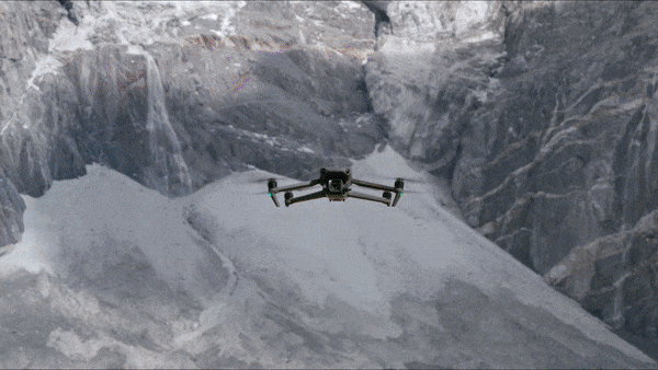
Compact drone optimised for aerial surveying
The DJI Mavic 3 Enterprise is a new generation of portable drone for land surveying.
Optimised for drone mapping, this lightweight all-in-one solution features a 4/3 inch 20MP sensor with mechanical shutter.
The DJI M3E is a highly-efficient surveying solution: A large pixel size, 0.7s shooting shutter interval and a 45 minute flight time means that it can cover up to 16km2 in a single day.
Combine with the RTK Module to achieve GCP-free, centimetre accurate mapping data.
A versatile solution, the Mavic 3 Enterprise can achieve up to 56x hybrid zoom, making it ideal for inspection missions.
Benefit from enhanced flight safety features, robust data security protocols and access to a full software suite, including DJI FlightHub 2.
Key Features
- Optimised for Surveying: Large pixel size
- Wide Camera: 4/3 CMOS camera; 20MP; Mechanical shutter
- Tele Camera: 12MP; 56x hybrid zoom
- Lightweight, compact, and portable: 915g airframe
- Ultra-long battery life: 45 minutes maximum flying time
- Enhanced Flight Safety: Omnidirectional obstacle sensing and advanced Return to Home
- Exclusive Controller: New DJI RC Pro Enterprise smart controller with high-bright screen.
- Accessories: Including RTK Module for centimetre-level precision.
- Full Software Suite: DJI Pilot 2; DJI FlightHub 2; DJI Terra.
- Entry-level Survey Drone: The price point and size makes the M3E a great entry level surveying drone.
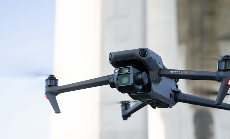
Camera
High-class sensor engineered for precision drone surveying
The camera on the Mavic 3 Enterprise enables it to be deployed as a specialised tool for aerial surveying and precision inspection missions.
Its integrated payload features wide and tele cameras.
The Mavic 3E’s large pixel size and Intelligent Low-Light Mode combine to offer significantly improved performance in dim conditions.
Wide Camera
- 4/3 CMOS sensor, 20MP
- Large pixel size (3.3um) and shooting interval of 0.7s increase surveying efficiency
- Mechanical shutter: Prevents motion blur and ensures no jelly effect under high-speed movement
- Equivalent focal length: 24mm
Tele Camera
- ½ inch CMOS, 12MP
- 162mm Equivalent Focal Length
- Up to 56x hybrid zoom
Enhanced Surveying Efficiency
More data in a single flight
The Mavic 3 Enterprise is more portable, efficient and expandable compared to DJI’s other compact drone mapping solution: The Phantom 4 RTK.
With greater battery life, larger pixel size and shorter shooting interval, the Mavic 3 Enterprise is up to eight times more efficient than the P4 RTK (1cm GSD).
Tests show that, with a 5cm GSD, the orthophoto efficiency of the Mavic 3 Enterprise can reach 2.25 square kilometres: 1.9 times that of the Phantom 4 RTK.
Next Generation Transmission And Safety Features
Greater peace of mind during flights
The Mavic 3 Enterprise has enhanced safety features, including improved obstacle sensing and navigation systems and equipped with a robust transmission system.
DJI O3 Enterprise Transmission: Benefit from a maximum control range of 8km (CE). DJI O3 Enterprise Transmission enables operators to transmit signals with higher stability and obtain a high frame rate live feed at 1080p/30fps.
DJI AirSense: Receive ADS-B signals from traditional aircraft in the area to warn of other air traffic nearby, for greater airspace awareness.
DJI APAS System 5.0: The new improved DJI APAS system 5.0 for obstacle sensing with zero blind spots is supported by six omnidirectional fish-eye sensors.
Advanced RTH: The drone automatically determines the optimal route back to its home point and executes it quickly.
Data Security
Protect your sensitive data
The Mavic 3 Enterprise offers state-of-the-art security features to protect the integrity of photos, videos, flight logs and other data generated during sensitive flight.
Local Data Mode: When activated, Local Data Mode stops the DJI Pilot 2 flight control app from sending or receiving any data over the internet. This provides added security assurances for operators of flights involving critical infrastructure, governmental projects or other sensitive missions.
AES-256 Encryption: The radio link between the aircraft and remote controller features robust AES-256 encryption, ensuring critical information exchanged between the drone and its remote is protected.
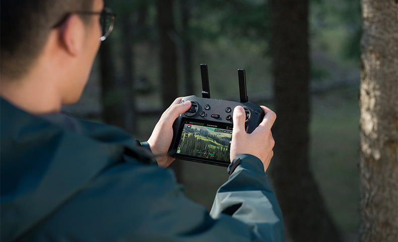
Controller
Professional remote controller for professional missions
The Mavic 3 Enterprise is compatible with the new DJI RC Pro Enterprise.
Key features of this professional remote controller include:
- 5.5-inch, 1,000-nit high-brightness screen for enhanced visibility in direct sunlight.
- Built-in microphone for clear communication. Can be used with the loud speaker module.
- 1.5 hours to fully charged, 3 hours of battery life
- Enhanced CPU and GPU performance
- Compatible with DJI Pilot 2, including route planning such as waypoint, mapping, oblique and linear.
Accessory Ecosystem
Get more from each flight
The Mavic 3 Enterprise is compatible with a range of enterprise-level accessories, increasing the effectiveness of each drone mission.
RTK Module: Enables surveying professionals to achieve centimetre-level accuracy with support for network RTK, custom network RTK services, and D-RTK 2 Mobile Station.
The D-RTK 2 Mobile Station: The Mavic 3 Enterprise is compatible with the D-RTK 2 Base Station - DJI’s upgraded high-precision GNSS receiver that supports all major global satellite navigation systems, providing real-time differential corrections.
Loud Speaker: Broadcast a message from above, with support for text-to-speech, audio storage, and looping.
Supported by DJI Enterprise Software
The Mavic 3 Enterprise Series drones are at the centre of an advanced and growing ecosystem of software for drone operations, allowing the aerial platforms to reach their full potential as tools for data gathering, mapping, fleet management and flight operations.
DJI Pilot 2
The revamped flight interface is designed to improve piloting efficiency and flight safety.
Drone and payload controls can be easily accessed with one tap. Users can access the drone's hardware, video live-stream, and photo data.
DJI Flighthub 2
This all-in-one cloud operations management software for drone fleets allows drone operators to efficiently manage flight operations with route planning and mission management.
DJI Terra
The full-featured mapping software for all stages of work, from mission planning to processing of 2D and 3D models.
To mark the launch of the Mavic 3 Enterprise Series, receive a free DJI Terra Electricity Licence for three months.
DJI Thermal Analysis Tool 3.0
Helps professionals analyse, annotate and process images captured by the Mavic 3 Thermal using DTAT 3.0 to detect temperature abnormalities during inspections.
Product Specifications
Aircraft
Weight (with propellers, without accessories) [1]
DJI Mavic 3E: 915 g
DJI Mavic 3T: 920 g
Max Takeoff Weight
DJI Mavic 3E: 1,050 g
DJI Mavic 3T: 1,050 g
Dimensions
Folded (without propellers): 221×96.3×90.3 mm (L×W×H)
Unfolded (without propellers): 347.5×283×107.7 mm (L×W×H)
Diagonal Distance
380.1 mm
Max Ascent Speed
6 m/s (Normal Mode)
8 m/s (Sport Mode)
Max Descent Speed
6 m/s (Normal Mode)
6 m/s (Sport Mode)
Max Flight Speed (at sea level, no wind)
15 m/s (Normal Mode)
Forward: 21 m/s, Side: 20 m/s, Backward: 19 m/s (Sport Mode) [2]
Max Wind Speed Resistance
12 m/s [3]
Max Take-off Altitude Above Sea Level
6000 m (without payload)
Max Flight Time (no wind)
45 mins [4]
Max Hover Time (no wind)
38 mins
Max Flight Distance
32 km
Max Tilt Angle
30° (Normal Mode)
35° (Sport Mode)
Max Angular Velocity
200°/s
GNSS
GPS+Galileo+BeiDou+GLONASS (GLONASS is supported only when the RTK module is enabled)
Hovering Accuracy
Vertical: ±0.1 m (with Vision System); ±0.5 m (with GNSS); ±0.1 m (with RTK)
Horizontal: ±0.3 m (with Vision System); ±0.5 m (with High-Precision Positioning System); ±0.1 m (with RTK)
Operating Temperature Range
-10° to 40° C (14° to 104° F)
Internal Storage
N/A
Motor Model
2008
Propeller Model
9453F Propellers for Enterprise
Beacon
Built into the aircraft
Wide Camera
Sensor
DJI Mavic 3E: 4/3 CMOS, Effective pixels: 20 MP
DJI Mavic 3T: 1/2-inch CMOS, Effective pixels: 48 MP
Lens
DJI Mavic 3E:
FOV: 84°
Format Equivalent: 24 mm
Aperture: f/2.8-f/11
Focus: 1 m to ∞
DJI Mavic 3T:
FOV: 84°
Format Equivalent: 24 mm
Aperture: f/2.8
Focus: 1 m to ∞
ISO Range
DJI Mavic 3E: 100-6400
DJI Mavic 3T: 100-25600
Shutter Speed
DJI Mavic 3E:
Electronic Shutter: 8-1/8000 s
Mechanical Shutter: 8-1/2000 s
DJI Mavic 3T:
Electronic Shutter: 8-1/8000 s
Max Image Size
DJI Mavic 3E: 5280×3956
DJI Mavic 3T: 8000×6000
Still Photography Modes
DJI Mavic 3E:
Single: 20 MP
Timed: 20 MP
JPEG: 0.7/1/2/3/5/7/10/15/20/30/60 s
JPEG+RAW: 3/5/7/10/15/20/30/60 s
Smart Low-light Shooting: 20 MP
Panorama: 20 MP (raw image)
DJI Mavic 3T:
Single: 12 MP/48 MP
Timed: 12 MP/48 MP
JPEG: 2/3/5/7/10/15/20/30/60 s*
Panorama: 12 MP (raw image); 100 MP (stitched image)
Smart Low-light Shooting: 12 MP
* Shooting 48MP photo does not support 2s interval
Video Resolution
H.264
4K: 3840×2160@30fps
FHD: 1920×1080@30fps
Bitrate
DJI Mavic 3E:
4K: 130 Mbps
FHD: 70 Mbps
DJI Mavic 3T:
4K: 85 Mbps
FHD: 30 Mbps
Supported File Formats
exFAT
Photo Format
DJI Mavic 3E: JPEG/DNG (RAW)
DJI Mavic 3T: JPEG
Video Format
MP4 (MPEG-4 AVC/H.264)
Tele Camera
Sensor
1/2-inch CMOS, Effective pixels: 12 MP
Lens
FOV: 15°
Format Equivalent: 162 mm
Aperture: f/4.4
Focus: 3 m to ∞
ISO Range
DJI Mavic 3E: 100-6400
DJI Mavic 3T: 100-25600
Shutter Speed
Electronic Shutter: 8-1/8000 s
Max Image Size
4000×3000
Photo Format
JPEG
Video Format
MP4 (MPEG-4 AVC/H.264)
Still Photography Modes
DJI Mavic 3E:
Single: 12 MP
Timed: 12 MP
JPEG: 0.7/1/2/3/5/7/10/15/20/30/60 s
Smart Low-light Shooting: 12 MP
DJI Mavic 3T:
Single: 12 MP
Timed: 12 MP
JPEG: 2/3/5/7/10/15/20/30/60 s
Smart Low-light Shooting: 12 MP
Video Resolution
H.264
4K: 3840×2160@30fps
FHD: 1920×1080@30fps
Bitrate
DJI Mavic 3E:
4K: 130 Mbps
FHD: 70 Mbps
DJI Mavic 3T:
4K: 85 Mbps
FHD: 30 Mbps
Digital Zoom
8x (56x hybrid zoom)
Thermal Camera [5]
Thermal Imager
Uncooled VOx Microbolometer
Pixel Pitch
12 μm
Frame Rate
30 Hz
Lens
DFOV: 61°
Format Equivalent: 40 mm
Aperture: f/1.0
Focus: 5 m to ∞
Sensitivity
≤50 mk@F1.1
Temperature Measurement Method
Spot Meter, Area Measurement
Temperature Measurement Range
-20° to 150° C (-4° to 302° F, High Gain Mode)
0° to 500° C (32° to 932° F, Low Gain Mode)
Palette
White Hot/Black Hot/Tint/Iron Red/Hot Iron/Arctic/Medical/Fulgurite/Rainbow 1/Rainbow 2
Photo Format
JPEG (8-bit)
R-JPEG (16-bit)
Video Resolution
640×512@30fps
Bitrate
6 Mbps
Video Format
MP4 (MPEG-4 AVC/H.264)
Still Photography Modes
DJI Mavic 3T:
Single: 640×512
Timed: 640×512
JPEG: 2/3/5/7/10/15/20/30/60 s
Digital Zoom
28x
Infrared Wavelength
8-14 μm
Infrared Temperature Measurement Accuracy
±2° C or ±2% (using the larger value)
Gimbal
Stabilization
3-axis (tilt, roll, pan)
Mechanical Range
DJI Mavic 3E:
Tilt: -135° to 100°
Roll: -45° to 45°
Pan: -27° to 27°
DJI Mavic 3T:
Tilt: -135° to 45°
Roll: -45° to 45°
Pan: -27° to 27°
Controllable Range
Tilt: -90° to 35°
Pan: Not controllable
Max Control Speed (tilt)
100°/s
Angular Vibration Range
±0.007°
Sensing
Type
Omnidirectional binocular vision system, supplemented with an infrared sensor at the bottom of the aircraft.
Forward
Measurement Range: 0.5-20 m
Detection Range: 0.5-200 m
Effective Sensing Speed: Flight Speed ≤15 m/s
FOV: Horizontal 90°, Vertical 103°
Backward
Measurement Range: 0.5-16 m
Effective Sensing Speed: Flight Speed ≤12 m/s
FOV: Horizontal 90°, Vertical 103°
Lateral
Measurement Range: 0.5-25 m
Effective Sensing Speed: Flight Speed ≤15 m/s
FOV: Horizontal 90°, Vertical 85°
Upward
Measurement Range: 0.2-10 m
Effective Sensing Speed: Flight Speed ≤6 m/s
FOV: Front and Back 100°, Left and Right 90°
Downward
Measurement Range: 0.3-18 m
Effective Sensing Speed: Flight Speed ≤6 m/s
FOV: Front and Back 130°, Left and Right 160°
Operating Environment
Forward, Backward, Lateral, and Upward: Surface with a clear pattern and adequate lighting (lux >15)
Downward: Diffuse reflective surface with diffuse reflectivity>20% (e.g. walls, trees, people) and adequate lighting (lux >15)
Video Transmission
Video Transmission System
DJI O3 Enterprise Transmission
Live View Quality
Remote Controller: 1080p/30fps
Operating Frequency [6]
2.400-2.4835 GHz
5.725-5.850 GHz
Max Transmission Distance (unobstructed, free of interference) [7]
DJI Mavic 3E:
FCC: 15 km
CE: 8 km
SRRC: 8 km
MIC: 8 km
DJI Mavic 3T:
FCC: 15 km
CE: 8 km
SRRC: 8 km
MIC: 8 km
Max Transmission Distance (Obstructed) [8]
Strong Interference (dense buildings, residential areas, etc.): 1.5-3 km (FCC/CE/SRRC/MIC)
Medium Interference (suburban areas, city parks, etc.): 3-9 km (FCC), 3-6 km (CE/SRRC/MIC)
Low Interference (open spaces, remote areas, etc.): 9-15 km (FCC), 6-8 km (CE/SRRC/MIC)
Max Download Speed[9]
15 MB/s (with DJI RC Pro Enterprise)
Latency (depending on environmental conditions and mobile device)
Approx. 200 ms
Antenna
4 Antennas, 2T4R
Transmission Power (EIRP)
2.4 GHz: <33 dBm (FCC), <20 dBm (CE/SRRC/MIC)
5.8 GHz: <33 dBm (FCC), <30 dBm (SRRC), <14 dBm (CE)
DJI RC Pro Enterprise
Video Transmission System
DJI O3 Enterprise Transmission
Max Transmission Distance (unobstructed, free of interference) [7]
FCC: 15 km
CE/SRRC/MIC: 8 km
Video Transmission Operating Frequency [6]
2.400-2.4835 GHz
5.725-5.850 GHz
Antenna
4 Antennas, 2T4R
Video Transmission Transmitter Power (EIRP)
2.4 GHz: <33 dBm (FCC), <20 dBm (CE/SRRC/MIC)
5.8 GHz: <33 dBm (FCC), <14 dBm (CE), <23 dBm (SRRC)
Wi-Fi Protocol
802.11 a/b/g/n/ac/ax
Support 2×2 MIMO Wi-Fi
Wi-Fi Operating Frequency [6]
2.400-2.4835 GHz
5.150-5.250 GHz
5.725-5.850 GHz
Wi-Fi Transmitter Power (EIRP)
2.4 GHz: <26 dBm (FCC), <20 dBm (CE/SRRC/MIC)
5.1 GHz: <26 dBm (FCC), <23 dBm (CE/SRRC/MIC)
5.8 GHz: <26 dBm (FCC/SRRC), <14 dBm (CE)
Bluetooth Protocol
Bluetooth 5.1
Bluetooth Operating Frequency
2.400-2.4835 GHz
Bluetooth Transmitter Power (EIRP)
< 10 dBm
Screen Resolution
1920×1080
Screen Size
5.5 inches
Screen
60 fps
Brightness
1,000 nits
Touchscreen Control
10-point multi-touch
Battery
Li-ion (5000 mAh @ 7.2 V)
Charging Type
Recommended to be charged with the included DJI USB-C Power Adapter (100W) or USB charger at 12 V or 15 V
Rated Power
12 W
Storage Capacity
Internal Storage (ROM): 64 GB
Supports a microSD card for expanded capacity.
Charging Time
Approx. 1 hour 30 minutes (with the included DJI USB-C Power Adapter (100W) only charging the remote controller or a USB charger at 15 V)
Approx. 2 hours (with a USB charger at 12 V)
Approx. 2 hours 50 minutes (with the included DJI USB-C Power Adapter (100W) charging the aircraft and remote controller simultaneously)
Operating Time
Approx. 3 hours
Video Output Port
Mini-HDMI port
Operating Temperature Range
-10° to 40° C (14° to 104° F)
Storage Temperature
-30° to 60° C (-22° to 140° F) (within one month)
-30° to 45° C (-22° to 113° F) (one to three months)
-30° to 35° C (-22° to 95° F) (three to six months)
-30° to 25° C (-22° to 77° F) (more than six months)
Charging Temperature
5° to 40° C (41° to 104° F)
Supported DJI Aircraft[10]
DJI Mavic 3E
DJI Mavic 3T
GNSS
GPS+Galileo+GLONASS
Dimensions
Antennas folded and controller sticks unmounted:
183.27×137.41×47.6 mm (L×W×H)
Antennas unfolded and controller sticks mounted:
183.27×203.35×59.84 mm (L×W×H)
Weight
Approx. 680 g
Model
RM510B
Storage
Supported Memory Cards
Aircraft:
U3/Class10/V30 or above is required. A list of recommended microSD cards can be found below.
Recommended microSD Cards
Remote Controller:
SanDisk Extreme PRO 64GB V30 A2 microSDXC
SanDisk High Endurance 64GB V30 microSDXC
SanDisk Extreme 128GB V30 A2 microSDXC
SanDisk Extreme 256GB V30 A2 microSDXC
SanDisk Extreme 512GB V30 A2 microSDXC
Lexar 667x 64GB V30 A2 microSDXC
Lexar High-Endurance 64GB V30 microSDXC
Lexar High-Endurance 128GB V30 microSDXC
Lexar 667x 256GB V30 A2 microSDXC
Lexar 512GB V30 A2 microSDXC
Samsung EVO Plus 64GB V30 microSDXC
Samsung EVO Plus 128GB V30 microSDXC
Samsung EVO Plus 256GB V30 microSDXC
Samsung EVO Plus 512GB V30 microSDXC
Kingston Canvas Go! Plus 128GB V30 A2 microSDXC
Kingston Canvas React Plus 128GB V90 A1 microSDXC
Aircraft:
SanDisk Extreme 32GB V30 A1 microSDHC
SanDisk Extreme PRO 32GB V30 A1 microSDHC
SanDisk Extreme 512GB V30 A2 microSDXC
Lexar 1066x 64GB V30 A2 microSDXC
Kingston Canvas Go! Plus 64GB V30 A2 microSDXC
Kingston Canvas React Plus 64GB V90 A1 microSDXC
Kingston Canvas Go! Plus 128GB V30 A2 microSDXC
Kingston Canvas React Plus 128GB V90 A1 microSDXC
Kingston Canvas React Plus 256GB V90 A2 microSDXC
Samsung PRO Plus 256GB V30 A2 microSDXC
Battery
Capacity
5000 mAh
Standard Voltage
15.4 V
Max Charging Voltage
17.6 V
Type
LiPo 4S
Chemical System
LiCoO2
Energy
77 Wh
Weight
335.5 g
Charging Temperature
5° to 40° C (41° to 104° F)
Charger
Input
100-240 V (AC Power), 50-60 Hz, 2.5 A
Output Power
100 W
Output
Max. 100 W (total)
When both ports are used, the maximum output power of each interface is 82 W, and the charger will dynamically allocate the output power of the two ports according to the load power.
Charging Hub
Input
USB-C: 5-20 V, 5.0 A
Output
Battery Port: 12-17.6 V, 8.0 A
Rated Power
100 W
Charging Type
Three batteries charged in sequence
Charging Temperature Range
5° to 40° C (41° to 104° F)
RTK Module
Dimensions
50.2×40.2×66.2 mm (L×W×H)
Weight
24±2 g
Interface
USB-C
Power
Approx. 1.2 W
RTK Positioning Accuracy
RTK Fix:
Horizontal: 1 cm + 1 ppm; Vertical: 1.5 cm + 1 ppm
Speaker
Dimensions
114.1×82.0×54.7 mm (L×W×H)
Weight
85±2 g
Interface
USB-C
Rated Power
3 W
Max Volume [11]
110 dB @ 1 m
Effective Broadcast Distance [11]
100 m @ 70 dB
Bit Rate
16 Kbps/32 Kbps
Operating Temperature Range
-10° to 40° C (14° to 104° F)
Other
Notes
[1] The standard weight of the aircraft (including the battery, propellers, and a microSD card). The actual product weight may vary due to differences in batch materials and external factors.
[2] Maximum speed in Sport mode is 19m/s when operating in EU regions.
[3] Max wind speed resistance during takeoff and landing.
[4] Measured with Mavic 3 Enterprise Series flying at a constant speed of 32.4 kph in a windless environment at sea level until the battery reached 0%. Data is for reference only. Please pay attention to RTH reminders in the DJI Pilot 2 app during flight.
[5] DO NOT expose the infrared camera lenses to strong sources of energy such as the sun, lava, or laser beams. Otherwise, the camera sensor may be burned, leading to permanent damage.
[6] In some countries and regions, the 5.8 and 5.1GHz frequencies are prohibited, or the 5.1GHz frequency is only allowed for indoor use. Check local laws and regulations for more information.
[7] Measured in an unobstructed environment free of interference. The above data shows the farthest communication range for one-way, non-return flights (with no payload) under each standard. During your flight, please pay attention to RTH reminders in the DJI Pilot 2 app.
[8] Data tested under different standards in unobstructed environments with typical interference. Uses for reference purposes only and provides no guarantee as to the actual flight distance.
[9] Measured in a laboratory environment with little interference in countries/regions that support both 2.4 GHz and 5.8 GHz. With footage saved on the officially recommended microSD cards. Download speeds may vary depending on actual conditions.
[10] Will support more DJI aircraft in the future. Visit the official website for the latest information.
[11] Data was measured in a controlled environment and is for reference only. Actual use experience may vary depending on software version, sound source, specific environment, and other conditions.
In the box
Mavic 3E Aircraft × 1
Mavic 3 Intelligent Flight Battery × 1
microSD Card 64GB × 1
Gimbal Protector × 1
Mavic 3 Enterprise Series Propellers (Pair) × 3
RC Pro Enterprise × 1
Screwdriver × 1
USB-C Power Adapter (100W) × 1
100W Power Adaptor AC Cable × 1
USB-C Cable × 1
USB-C to USB-C Cable × 1
Protector Case × 1
WHY BUY FROM US?
By buying from Ferntech, you'll have the confidence that you are dealing directly with New Zealand's leading drone experts. Our staff are knowledgable drone pilots who offer expert advice, trusted support and superior specialist service. Only through us will you receive a full New Zealand warranty, phone and email support, and access to our certified Repairs Centre with DJI-qualified drone technicians. And we guarantee that we will have the best prices on the market — if not let us know and we will match any price (conditions apply).
Warranty Details
- What are the highlights of the Mavic 3 Enterprise Series? What's the difference with the consumer Mavic 3?
- Mavic 3 Enterprise Series include two models: M3E (Mavic 3 Enterprise) and M3T (Mavic 3 Thermal).
- With RTK module and mechanical shutter, M3E can achieve centimeter-level mapping accuracy, which is a significant improvement compared to decimeter-level accuracy of the consumer Mavic 3 (No RTK and electronic shutter only). In addition, M3E uses DJI Pilot 2 app, which can be used for route planning and mission flight. Compared with the DJI Fly app, which is used to control consumer Mavic 3, Pilot 2 pilot has more enterprise features.
- M3T integrates 640*512@30Hz thermal camera, which can be used for night patrol and abnormal temperatures detection, suitable for power grid inspection, solar farm inspection, SAR, firefighting, etc.
- Regarding the camera spec, both M3E & M3T support 56x hybrid zoom, while Mavic 3 supports 28x hybrid zoom. The minimal photo interval of M3E wide camera is improved to 0.7 seconds, which significantly improves the mapping efficiency.
- Mavic 3 Enterprise Series provide RTK, speaker and support both MSDK and PSDK for 3rd party software and hardware, which can meet the different types of requirements of enterprise users.
- What are the improvements of M3E compared to P4R?
- Longer Endurance and Higher Efficiency: M3E supports maximum 42min flight time (with RTK module), 15m/s flight speed and 0.7s minimum photo interval, while P4R supports maximum 30min flight time, 13m/s flight speed and 2.5s minimum photo interval. So, the M3E can complete over 2 square kilometers 2D mapping area in a single flight (GSD=5cm), which is 2 times that of the P4R. (When the GSD is smaller, the advantage of M3E is greater. When GSD=1cm, the efficiency of M3E is 7 times that of P4R.)
- Better Photo Quality: The 4/3-inch CMOS sensor of M3E brings better color reproduction and better noise reduction in low light.
- Improved Flight Safety: M3E integrates Multiple wide-angle vision sensors which provides omnidirectional obstacle sensing. The flight is safer and more reliable.
- More Stable Video Transmission: M3E incorporates O3 Enterprise video transmission technology, which offers maximum 15km (FCC standard) transmission distance and 1080P low-latency video.
- The altitude limit is increased from 500 meters to 1500 meters, supports panoramic photography, and more powerful controller.
- What are the improvements of M3T compared to M2EA?
- Longer endurance: M3E supports maximum 45min flight endurance, while M2EA supports maximum 31min flight time. The longer flight time of the M3T can greatly improve the operation efficiency in the inspection scenario.
- Tele Camera: Compared to the M2EA which integrates wide and infrared camera, the M3E has an additional zoom camera that can be used for long-distance scouting.
- Improved Flight Safety: M3T integrates Multiple wide-angle vision sensors which provides omnidirectional obstacle sensing. The flight is safer and more reliable.
- More Stable Video Transmission: M3T incorporates O3 Enterprise video transmission technology, which offers maximum 15km (FCC standard) transmission distance and 1080P low-latency video.
- Support FH2: Livestreaming, Coordinate synchronization, Media file sharing
- What is the mapping accuracy of M3E?
M3E GCP-free accuracy is about 2 times that of GSD. For example, at 100m flight height, GSD=H/37=2.7cm, accuracy is within 5.4 cm
- Which industries are Mavic 3 Enterprise Series suitable for?
- M3E is suitable for surveying and mapping, power grid inspection, wind farm inspection, etc.
- M3T is suitable for power grid inspection, solar farm inspection, SAR, firefighting, etc.
- Which apps are compatible with Mavic 3 Enterprise Series?
DJI Pilot2 and 3rd party app via MSDK.
- Does Mavic 3 Enterprise Series support SDK?
Support MSDK, PSDK and Cloud API.
- Comparison between Mavic 3 Enterprise Series, M30 Series and M300 RTK
- M3E/M3T: Foldable and compact design, easy to carry, entry-level enterprise drone.
- M30/M30T: 16x optical zoom and LRF, IP55, powerful RC Plus, suitable for customers who have high requirements for the zoom performance, ingress protection and flight control experience.
- M300: Support mounting H20 series, P1, L1 and variety o 3rd party payloads, suitable for customers who have high requirement for payload.
There's currently no reviews for this product, be the first to write one.


