DJI Zenmuse L1 (LiDAR)

WAS $24,380.00 NOW $12,190.00
LAST UNIT IN STOCK HALF PRICE
SKU: L1

The Zenmuse L1 integrates a Livox LiDAR module, a high-accuracy IMU, and a camera with a 1-inch CMOS on a 3-axis stabilized gimbal.


Only 1 Left!

Auckland Click & Collect: Available

  • Free Shipping on all orders over $300
  • Order before 2.00pm for same day dispatch
  • Click & collect from Auckland & Christchurch stores
  • Local warranty, support and repairs

Through Ferntech you get FREE Enterprise Shield Cover with your L1


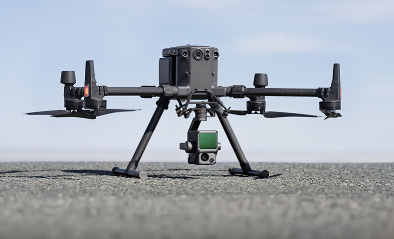
The Zenmuse L1 integrates a Livox Lidar module, a high-accuracy IMU, and a camera with a 1-inch CMOS on a 3-axis stabilized gimbal. When used with Matrice 300 RTK and DJI Terra, the L1 forms a complete solution that gives you real-time 3D data throughout the day, efficiently capturing the details of complex structures and delivering highly accurate reconstructed models.


Key Features


Digitize without Compromise

Exceptional Efficiency
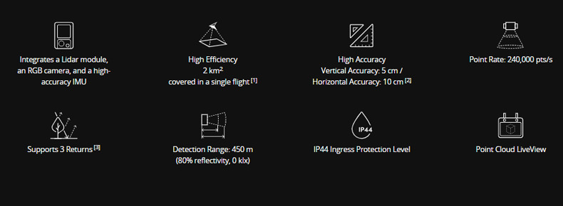
Generate true-color point cloud models in real-time, or acquire 2 km2 of point cloud data in a single flight [1] using the Livox frame Lidar module with a 70° FOV and a visible light camera with a 1-inch sensor.

Unparalleled Accuracy
Render centimeter-accurate reconstructions thanks to the high-accuracy IMU, a vision sensor for positioning accuracy, and the incorporation of GNSS data.

Ready When You Are
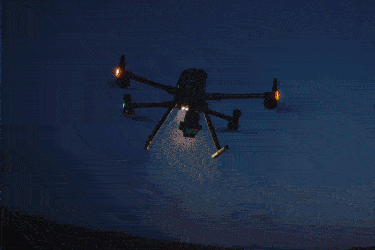
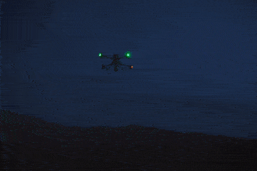
The IP44 rating allows the L1 to be operated in rainy or foggy environments. The Lidar module’s active scanning method enables you to fly at night.


Visualise Data As You Fly

Livox Lidar Module
- Frame Lidar with up to 100% effective point cloud results
- Detection Range: 450m (80% reflectivity, 0 klx) / 190 m (10% reflectivity, 100 klx)
- Effective Point Rate: 240,000 pts/s
- Supports 3 Returns
- Line Scan Mode and Non-repetitive Scan Mode


Everything in View

RGB Camera
- 20MP
- 1-inch CMOS
- Mechanical Shutter


Accurate Details at Your Disposal

High-accuracy IMU
- Accuracy: 0.025° (roll/pitch) / 0.08° (yaw)
- Vision Sensor for Positioning Accuracy
- GNSS, IMU, RGB Data Fusion


Recreate the World in 3D Point Clouds


Point Cloud LiveView
Real-time point clouds provide immediate insights onsite, so operators are informed to make critical decisions quickly.
You can also verify fieldwork quality by checking point cloud data immediately after each flight.

Measurement and Annotation
Acquire and communicate critical dimensions on the point cloud model using measurements and annotations.

One-stop Post-processing
DJI Terra fuses the IMU and GNSS data for point cloud and visible light calculations, in addition to conducting POS data calculations so you can effortlessly generate reconstructed models and accuracy reports.

Contact us for more information


Product Specifications

General

Dimensions: 152×110×169 mm
Weight Approx: 900 g
Power: 30 W
IP Rating: IP44
Supported Aircraft: Matrice 300 RTK
Operating Temperature Range: -20° to 50° C (-4° to 122° F)
Storage Temperature Range: -20° to 60° C (-4° to 140° F)
 

System Performance

Detection Range: 450 m @ 80% reflectivity, 0 klx <br>;190 m @ 10% reflectivity, 100 klx
Point Rate Single return: 240,000 pts/s <br>;Multiple return: 480,000 pts/s
System Accuracy Horizontal: 10 cm @ 50 m <br>;Vertical: 5 cm @ 50 m
Real-time Point Cloud Coloring Modes: True color; coloring by reflectivity; coloring by elevation
 

LiDAR

Ranging Accuracy: 3 cm @ 100 m
Maximum Returns Supported: 3
Scan Modes: Repetitive line scan mode, non-repetitive petal scan mode
FOV: Repetitive line scan: 70.4°×4.5°<br>; Non-repetitive petal scan: 70.4°×77.2°
Laser Safety: Class 1
 

Inertial Navigation System

IMU Update Frequency: 200 Hz
Accelerometer Range: ±8 g
Angular Velocity Meter Range: ±2000 dps
Yaw Accuracy: Real-time: 0.18°, Post-processing: 0.08°
Pitch / Roll Accuracy: Real-time: 0.03°, Post-processing: 0.025°
 

Auxiliary Positioning Vision Sensor

Resolution: 1280×960
FOV: 95°
 

RGB Mapping Camera

Sensor Size: 1 inch
Effective Pixels: 20 MP
Photo Size: 4864×3648 (4:3); 5472×3648 (3:2)
Focal Length: 8.8 mm / 24 mm (Equivalent)
Shutter Speed: Mechanical Shutter Speed: 1/2000 - 8 s / Electronic Shutter Speed: 1/8000 - 8 s
ISO: Video: 100 – 3200 (Auto), 100 – 6400 (Manual) 
Photo: 100 - 3200 (Auto), 100 - 12800 (Manual)"
Aperture Range: f/2.8 - f/11
 

Gimbal

Stabilized System: 3-axis (tilt, roll, pan)
Angular Vibration Range: 0.01°
Mount: Detachable DJI SKYPORT
Mechanical Range: Tilt: -120° to +30°; Pan: ±320°
Operation Modes: Follow/Free/Re-center
 

Data Storage

Raw Data Storage: Photo/IMU/Point cloud data storage
Point Cloud Data Storage: Real-time modeling data storage
Supported microSD Cards: microSD: Class 10 or UHS-1 rating or above; Max capacity: 256 GB
 

Post-processing Software

Supported Software: DJI Terra
Data Format: DJI Terra supports exporting standard format point cloud models:
Point cloud format: PNTS/LAS/PLY/PCD/S3MB format
Reconstruction model format: B3DM/OSGB/PLY/OBJ/S3MB format
 

In the box

WHY BUY FROM US?

By buying from Ferntech, you'll have the confidence that you are dealing directly with New Zealand's leading drone experts. Our staff are knowledgable drone pilots who offer expert advice, trusted support and superior specialist service. Only through us will you receive a full New Zealand warranty, phone and email support, and access to our certified Repairs Centre with DJI-qualified drone technicians. And we guarantee that we will have the best prices on the market — if not let us know and we will match any price (conditions apply).


Warranty Details

What is the protection level of the Zenmuse L1?
The L1 has an IP44 rating according to the IEC60529 standard. This means that it is protected against solid objects over 1mm in size and against water splashed from all directions. The protection level is not permanent however and will decrease over time due to device wear.
  To ensure the highest levels of protection:
  • Before installing, make sure that the interface and surface of the gimbal are dry;
  • Before use, make sure that the gimbal is firmly installed on the drone and the SD card protective cap is clean, free of foreign objects, and closed;
  • Before opening the SD card protective cap, wipe the surface of the drone clean."
 
What aircraft is the L1 compatible with?
The L1 is compatible with the M300 RTK. Before using, please upgrade the firmware of the drone and remote controller to the latest version.
 
Which apps are compatible with the L1?
The L1 currently supports only the Android version of the DJI Pilot App.
 
Does the camera require an SD card?
The camera requires a MicroSD card with Class 10 or higher transmission speed or rated UHS-1 , with up to 256 GB supported.
 
What is the Field of View (FOV) of the L1's Lidar?
In Non-repetitive Scanning mode, the FOV is 70.4°x77.2°.
In Repetitive Scanning mode, the FOV is 70.4°x4.5°.
 
What is the maximum measuring range of the L1?
The maximum measuring range of the L1 is 190m@10%, 100klx ; 450m@80%, 0klx.
The recommended typical working height is 50m-150m.
 
What is the scanning frequency of the L1?
The L1 provides three scanning frequencies: one/two returns: 80K/s, 160K/s, and 240K/s; three returns: 80K/s, 240K/s.
 
How many scanning modes does the L1 have?
The L1 has two scanning modes: Non-repetitive Scanning mode and Repetitive Scanning mode.
 
How many returns does the L1 support?
The L1 supports 4 types of returns:One return: highest intensity; One return: first return; Two returns; Three returns.[TR2]
 
What does the L1's Point Cloud LiveView do?
The L1 collects point cloud models based on RTK and displays the collected models on Pilot in real time.
  The following features are supported: 
  · Rotating, dragging, zooming, quick switching of perspectives, and centering;
  · Multiple coloring modes including RGB, reflectivity, and elevation;
  · Basic measurement functions including distance, angle, and plane area;
  · Importing data into DJI Terra to display directly."
 
How does the L1 perform high-accuracy post-processed modeling?
For high-accuracy post-processed modeling, you can import the data from the SD card into DJI Terra with one click. This will generate a colorized point cloud model with high-accuracy PPK-IMU position and orientation calculation supported.
 
Which model reconstruction formats does the L1 support?
The L1 supports the following model reconstruction formats:
  · Point cloud formats: PNTS, LAS, PLY, PCD and S3MB; 
  · Model formats: B3DM, OSGB, PLY, OBJ and S3MB.
 
Which types of flight missions does the the L1 support?
The L1 currently supports 2D Orthomosaic and Corridor Mapping flight missions.
Does the L1 support ground-based data collection? The L1 supports ground-based stationary 360° model data collection.
 
What is the IMU accuracy of the L1?
In typical operating scenarios, the IMU accuracy of the L1 is 0.025°(roll/pitch)/0.08°(yaw).
 
What is the L1's auxiliary vision sensor used for?
The vision sensor provides altitude data. This means that if the GNSS signal temporarily fails, the aircraft's accuracy will not be affected for up to 60 seconds.
 
What is the L1's RGB camera used for?
The RGB camera of the L1 provides basic functions for taking photos and recording videos and provides real-time color information for the point cloud data during the scanning process. This allows the L1 to output true color point clouds and reality models. 
Note that Lidar scanning and video recording cannot work simultaneously.
 
Which measurement operations can be performed during real-time point cloud rendering?
During real-time point cloud in the Pilot, the point, line and plane measurements can be performed.
 
What is the surveying and mapping accuracy of the L1?
At a flight height of 50 m, the vertical accuracy of the L1 can reach 5 cm and the horizontal accuracy can reach 10 cm.
 
Can the L1 work at night?
The Lidar module of the L1 has active detection capability which can scan terrain to collect point clouds during nighttime or other low light conditions.
 
Which scanning mode does the L1's Lidar module adopt?
The Lidar module of the L1 adopts an Advanced Frame Scanning mode. This ensures that all point clouds collected are valid point cloud data.
 
How efficient is the surveying and mapping operation of the L1?
At a flight height of 100 m and a velocity of 10 m/s, a single flight with the M300 RTK and the L1 can collect data covering an area of 2 km2.
 
What are the application scenarios of the Zenmuse L1?
The L1 can be wid

There's currently no reviews for this product, be the first to write one.

Write a product review