


MetScan V1 + AIRINS.ai (For M400)
The MetScan V1 + AIRINS.ai solution is an integrated UAV-based methane 3D screening system designed for efficient leak detection in the natural gas industry.
Features
The MetScan V1 + AIRINS.ai solution is an integrated UAV-based methane 3D screening system designed for efficient leak detection in the natural gas industry. By combining high-precision laser spectroscopy with intelligent software, this system allows operators to detect, locate, and visualize methane emissions from a safe distance.
Core Components
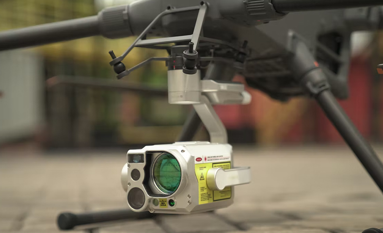
MetScan V1 (Hardware): A UAV-mounted methane 3D screening payload weighing approximately 890 g.
AIRINS.ai / SSI (Software): The Soarability Spatiotemporal Insights (SSI) platform—integrated with AIRINS.ai—provides browser-based data analysis, live monitoring, and 3D visualization.
DJI Matrice 400/350 Integration: The system is "Plug & Play" for DJI Matrice 400/350 and supports DJI PSDK, allowing full control and real-time data viewing within the DJI Pilot 2 App.
Hardware Capabilities
Detection Technology: Uses Open-Path Tunable Diode Laser Absorption Spectroscopy (OP-TDLAS) to detect fugitive gas emissions from a safe distance.
High-Speed Sampling: Features a measurement frequency of up to 50 Hz for dense data collection.
3-Axis Stabilized Gimbal: An in-house designed and tuned three-axis gimbal ensures pinpoint laser measurements and clear imagery even from a long distance.
Dual-Camera System: Integrated 35 mm (equiv.) wide-angle and 300 mm (equiv.) telephoto cameras enable real-time dual-view fusion.
Laser Rangefinder: Integrated laser rangefinder provides distance measurements to targets up to 800 m in low-light and 500 m in daytime.
Performance Specifications
Effective Measurement Range: 100 to 99,999 ppm-m.
Verified Detection Distance: Typical results show 1,000 ppm-m clouds detected at 75 m (sunny) and 2,500 ppm-m clouds at 100 m (cloudy).
Ingress Protection: IP54 rated for protection against dust and water splashes.
AIRINS.ai / SSI Software Features
Advanced Visualization: Supports 2D and 3D visualization, including methane concentration point clouds, grid heatmaps, ray (line) projection, and interpolated heatmaps.
Intelligent Sweeping: Supports 1D and 2D sweeping patterns for automated facility screening.
Closed-Loop Analysis: Features one-click positioning and navigation to leak points via Google Maps or Waze.
Real-Time Data Streaming: Supports MQTT protocol for real-time data forwarding to command centers or SCADA systems.
Application Scenarios
Natural Gas Wells: Captures leaks from valves, flanges, and other components from a distance at the centimeter level.
Gas Pipelines: Acquires dense methane concentration data along aboveground and underground pipelines using automated belt-type scanning.
High-Rise Buildings: Captures natural gas leaks inside (through windows) and outside residences, automatically estimating relative altitude to pinpoint risk areas.
Product Specifications
General
Dimensions: Approx. 192 x 129 x 172 mm (L x W x H, including the gimbal)
Weight: Approx. 890 g (including the gimbal).
Ingress Protection Rating: IP54.
Special Features
DJI PSDK Support: Enables control of the MetScan V1 and real-time data viewing directly within DJI Pilot 2 App
Intelligent Sweeping Modes: Supports 1D and 2D sweeping patterns.
Laser Spot Position Estimation: Outputs the geographic coordinates (longitude, latitude), and relative altitude of the laser spot on the target surface.
Remote Sensing Methane Sensor
Method of Detection: Open-Path Tunable Diode Laser Absorption Spectroscopy (OP-TDLAS).
Laser Class: Class 3R, avoid direct eye exposure.
Effective Measurement Range: 100 ~ 99,999 ppm·m.
Measurement Error: ≤10% (1,000 ~ 50,000 ppm·m at 20 m).
Measurement Frequency: Up to 50 Hz.
Maximum Detection Distance (MDD) & Lowest Detection Limit (LDL):
- Influenced by several factors:
Size & concentration of the gas cloud
Surface reflection intensity (ideal at 90° incidence) and consistency
Sunlight interference
Laser movement speed - Typical results of the MDD and LDL:
1,000 ppm·m gas cloud (PMMA cube) continuously detected at 75 m under sunny conditions (3:30pm, stationary, vertical test).
2,500 ppm·m gas cloud (PMMA cube) continuously detected at 100 m under cloudy conditions (2:30pm, stationary, vertical test).
Imaging System
Wide-Angle Camera: Approx. 35 mm equivalent focal length.
Telephoto Camera: Approx. 300 mm equivalent focal length.
Display & Recording: Simultaneous dual-camera display in DJI Pilot 2 App and mission-synchronized video recording.
Stabilised Gimbal
Three-Axis Stabilization: Yaw, Pitch, Roll.
Compatibility: DJI Matrice 400/350.
Laser Rangefinder
Maximum Detection Distance (Nighttime): 800 m.
Maximum Detection Distance (Daytime): 500 m.
Data Analytical Software
Software Platform: Soarability Spatiotemporal Insights (SSI).
Capabilities: Provides advanced real-time & historical mission analysis, visualization, and report generation.
In the box
MetScan + AIRINS.ai (for M400) × 1
WHY BUY FROM US?
By buying from Ferntech, you'll have the confidence that you are dealing directly with New Zealand's leading drone experts. Our staff are knowledgable drone pilots who offer expert advice, trusted support and superior specialist service. Only through us will you receive a full New Zealand warranty, phone and email support, and access to our certified Repairs Centre with DJI-qualified drone technicians. And we guarantee that we will have the best prices on the market — if not let us know and we will match any price (conditions apply).
Warranty Details
There's currently no reviews for this product, be the first to write one.


