


Pix4Dmatic
Next-generation photogrammetry software for corridor and large scale mapping
Features
Accurate, fast drone mapping on a new scale
Pix4Dmatic is designed to work with the latest generation of drones for professional applications and transforms your large number of images into accurate point clouds, DSMs and orthomosaics.
Bigger datasets, accurate results
Pix4Dmatic processes thousands of images while maintaining survey-grade accuracy, halving the processing time, without the trouble of splitting and merging.
Fully automated processing
Developed in close-collaboration with surveyors and mapping professionals to streamline your workflow: import, process and assess the quality of a project in just a few clicks, and move seamlessly from Pix4Dmatic to Pix4Dsurvey.
Future-proofed for BVLOS
Pix4Dmatic is ready to support the large datasets generated by BVLOS* (beyond visual line of sight) drone flights.
*Where legally permitted
Accurate 3D maps and models from thousands of images
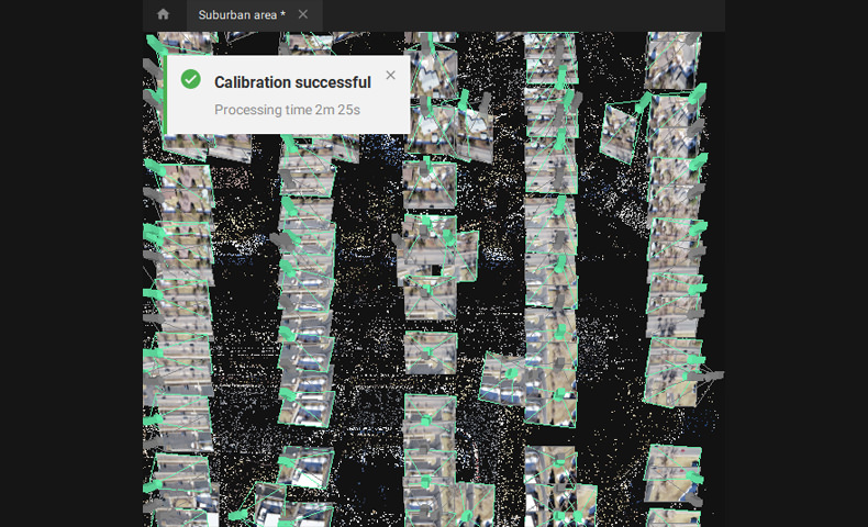
FAST PROCESSING
Handling and processing large amounts of data is easy with Pix4Dmatic.
Get your results up to 50% faster, while keeping a survey-grade accuracy.
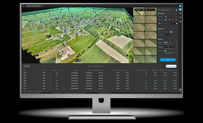
EASY ACCURACY CHECKS
Ensure the accuracy of your project with GCPs, Checkpoints, or Manual Tie Points. Accuracy metrics are available in a dedicated tie points table and in an exportable quality report.
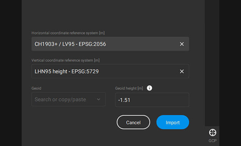
VERTICAL COORDINATE SYSTEMS AND GEOID SUPPORT
Pix4Dmatic supports the most frequently used vertical coordinate systems and their corresponding geoids.
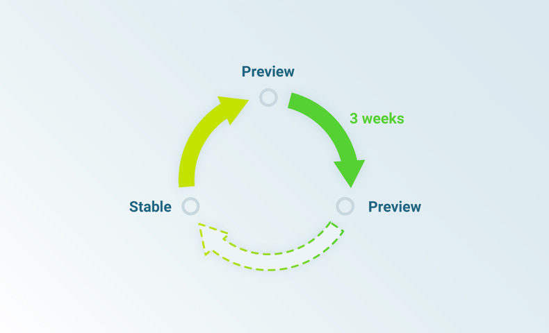
FAST DEVELOPMENT CYCLES
Updates are released every three weeks in a new preview or stable version, ensuring you get all the latest improvements and features.
Essential outputs, in a fraction of the time
without compromising accuracy
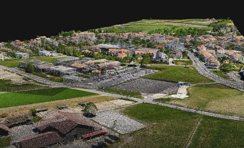
Dense point cloud
Generate dense point clouds for large areas. Each point of the point cloud receives the RGB value of the raster pixel that has the same location.
Export formats: .las
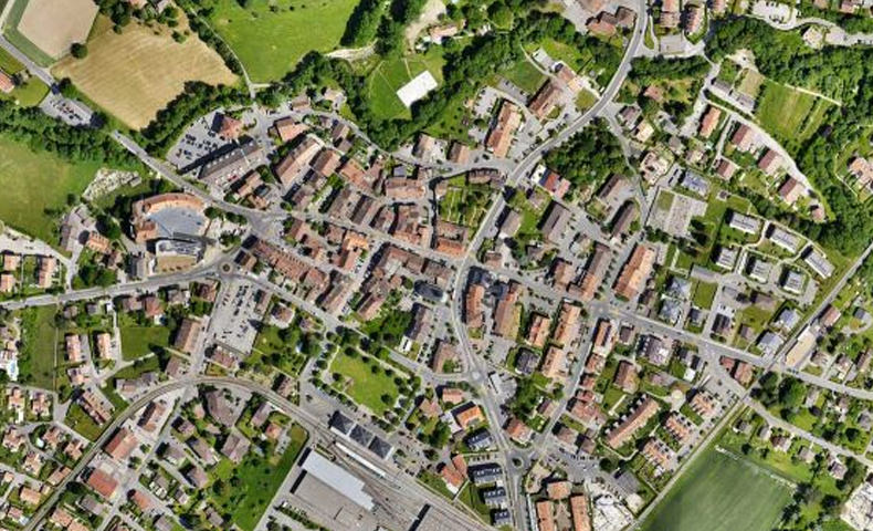
Orthomosaic
Create orthomosaics that are geometrically corrected such that the scale is uniform. They are color balanced in order to be visually pleasing.
Export formats: GeoTIFF (.tiff)
.jpg)
Digital surface model (DSM)
Generate a digital representation of all objects in the mapped area. It includes natural features as well as elevated objects, like buildings.
Export formats: GeoTIFF (.tiff)
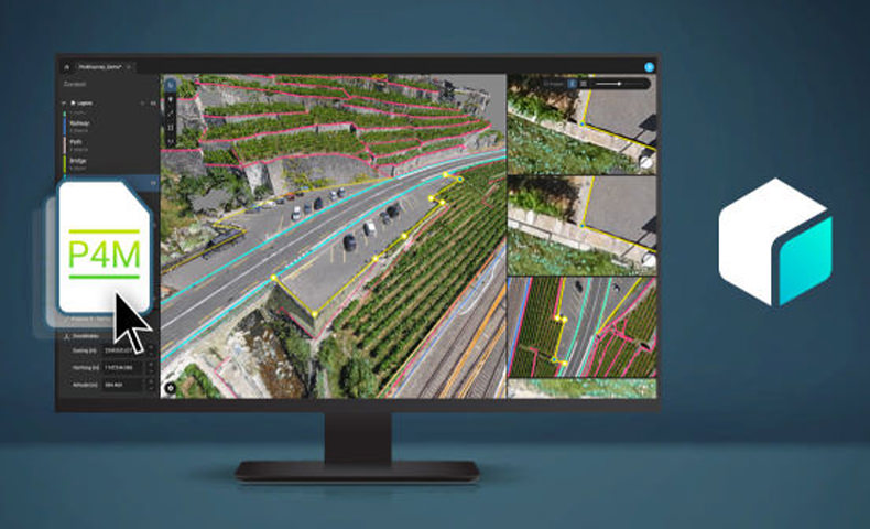
Compatible with Pix4Dsurvey
Seamless export of processed projects into Pix4Dsurvey to transform point clouds into actionable CAD-ready data. Pix4D's proprietary .bpc file format is optimized for loading and manipulation of big point clouds.
Export format: .p4m
Product Specifications
Inputs |
Features |
Advantages |
| Aerial (nadir and oblique) and terrestrial imagery |
Process images taken at any angle and from any aerial manned or unmanned platform as well as from the ground |
|
| Video (mp4 or avi format) | Automatically extracts still frames from video files to create a project | |
| Any camera (compact, SLR, thermal, multispectral, GoPro, 360-degree, largeframe add-on, etc.) images in .jpg or .tiff |
Use images acquired by any camera, from small to large frames, from consumer-grade to highly specialized cameras |
|
| Multi-camera support for the same project | Create a project using images from different cameras and process them together | |
| Camera rig support | Process images using known rig relatives from multiple synchronized cameras, customized or from known manufacturers for more robust, accurate and faster processing |
|
| Ground control point edit and import | Import and edit ground control points to improve the absolute accuracy of your project | |
| Known or custom reference coordinate system support in imperial or metric units |
Select EPSG code from known coordinate systems or define your own local system | |
| Camera exterior orientation support | Optimize camera exterior orientation parameters starting from GPS and IMU input parameters | |
| External point cloud import | Import a point cloud from different sources, such as LiDAR, and use it to create a DSM and orthomosaic | |
Processing |
Processing templates | Automate processing and generation of outputs by using standard or customized templates |
| Rapid Check with Quality Report | Rapid processing template for a dataset quick check while still on site | |
| Camera self-calibration | Optimize internal camera parameters, such as focal length, principal point of autocollimation and lens distortions | |
| Rolling shutter effect correction | Correct the warp of images taken with rolling shutter cameras (like GoPro, DJI Phantom 2 and 3, etc.) to maintain good accuracy, especially useful when flying fast and low. |
|
| Automatic Aerial Triangulation (AAT) and Bundle Block Adjustment (BBA) |
Process with or without known camera exterior orientations: (x, y, z, omega, phi, kappa) | |
| Automatic point cloud densification | Produce a dense and detailed 3D point cloud, which can be used as a basis for DSM and 3D mesh | |
| Automatic point cloud filtering & smoothing |
Use presets for point cloud filtering and smoothing options | |
| Machine-learning point cloud classification |
Automatically classify the RGB dense point cloud into five groups: ground, road surfaces, high vegetation, buildings and human-made objects |
|
| Automatic DTM/DEM extraction | Remove above-ground objects from DSM and create a bare-Earth model. For additional control, select and delete points manually in the rayCloud to improve DTM/DEM generation |
|
| Automatic brightness and color correction | Compensate automatically for change of brightness, luminosity and color balancing of images | |
| Automatic outlier detection | Detect incorrectly-clicked MTPs/GCPs to reduce human errors | |
| Quality Report |
Assess the accuracy and quality of projects | |
| Project merging and splitting | Combine multiple projects into one or split large projects into several for more efficient processing | |
| Project area definition |
Import (.shp) or draw specific areas to faster generate results inside specific boundaries | |
| Targeted Feature Extraction | Give the number of features to find, getting more features in low-texture images to assist the reconstruction or less features for large-frame images to speed up processing |
|
| Multiprocessor CPU + GPU support | Increase the processing speed by leveraging the power of CPU cores and threads, as well as GPUs | |
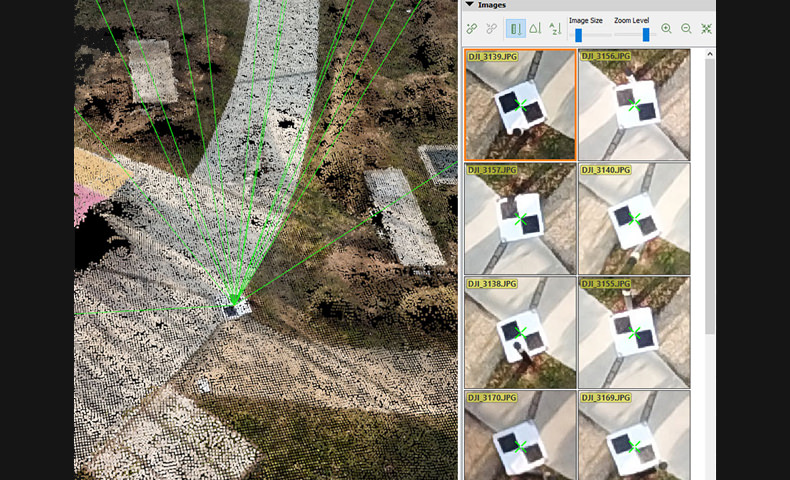
| Raycloud Editor | Project visualization |
Assess quality of optimized camera positions, 3D point cloud and mesh |
| Navigation modes | View 3D point cloud and mesh in standard, trackball, or first person viewing modes | |
| Scale Constraint |
Accurately scale projects with no or imprecise geolocation by defining one/multiple distances | |
| Orientation Constraint | Orientate projects with no or imprecise geolocation by defining directions of one/multiple axes | |
| Ground control point (GCP ) / Manual tie point (MTP) editing |
Annotate and edit 2D and 3D ground control points (GCPs), check points and manual tie points with the highest accuracy, using both original images and 3D information at the same time | |
| Project reoptimization | Reoptimize camera positions and/or rematch images based on GCPs and manual tie points to improve reconstruction of difficult areas |
|
| Image masking | Carve: Remove points from 3D point cloud and create filters based on image content. Mask: Clear the unwanted background in orthoplane results. Global Mask: Disregard objects which appear in all images, such as a drone leg or tripod which occluded the lens during all image acquisition. |
|
| Point cloud editing |
Select, classify or delete points from the point cloud using various selection tools | |
| Orthoplane creation | Define a plane to generate a DSM and orthomosaic from building facades, bridge piles, etc | |
| Polyline and surface object creation | Annotate and measure polylines and surfaces in the point cloud. Accurately refine vertexes in multiple original images. |
|
| 3D mesh and DSM editing | Annotate and create surfaces in the point cloud to flatten an area, or to fill up holes in the mesh and DSM caused by insufficient image content. |
|
| Fly-through animation | Create a virtual camera trajectory in 3D rayCloud viewer, play the animation in real-time, export the animation as a video (in mp4 and avi format) and the editable flightpath waypoints in .csv format |
|
| Volume Manager | Volume object creation | Annotate and measure volumes based on the DSM |
| Volume object management | Import and export selected volume bases in .shp files to enable easy monitoring of stockpiles on site. | |
| Base adjustment | Adjust the reference base to fit different terrain and obtain accurate measurement | |
| Mosaic Editor | Region editing |
Create and edit regions on the orthomosaic, choose the best content from multiple underlying images and projection type to remove moving objects or artifacts |
| Local blending | Edit only the desired portion of the orthomosaic, blend it in real-time and get the improved orthomosaic within minutes |
|
| Planar or ortho projection selection | Select planar or ortho projection for each created region to remove artifacts | |
| Index Calculator | Reflectance map |
Generate an accurate Reflectance map at the preferred resolution as a basis of index maps target |
| Radiometric adjustment interface | Make the reflectance maps more reliable and accurate by correcting illumination effects using a radiometric |
|
| Multiple region management |
Improve your analysis by managing and visualizing index values per region | |
| Automatic NDVI map | Generate singleband and NDVI maps based on pre-defined formulas without user intervention | |
| Index formula editing |
Create and save your own formulas choosing among each available input band and generate custom index maps |
|
| Class management | Create a basis of your annotated vector map by segmenting the data into classes using statistical algorithms (equal spacing, equal area, Jenks) |
|
| Prescription annotation |
Match on-site scouts and observations by assigning annotations based on your decisions | |
| Prescription map export | Put your data into action and export the prescription map in .shp format |
In the box
WHY BUY FROM US?
By buying from Ferntech, you'll have the confidence that you are dealing directly with New Zealand's leading drone experts. Our staff are knowledgable drone pilots who offer expert advice, trusted support and superior specialist service. Only through us will you receive a full New Zealand warranty, phone and email support, and access to our certified Repairs Centre with DJI-qualified drone technicians. And we guarantee that we will have the best prices on the market — if not let us know and we will match any price (conditions apply).
Warranty Details
There's currently no reviews for this product, be the first to write one.
Related Products

Contact for Pricing

Contact for Pricing

$499.00


